| The file available from ... |
Direct link |
| 31 December 2009 |
Curriculum of Cartography MSc |
| 5 March 2005 |
Virtual
exhibition (addition to the exhibition "Hungary on maps"
opened in London) |
| 15 February 2005 |
Photos of István
Klinghammer's lecture in the Hungarian Academy of Science |
| 30 January 2005 |
Photos of the final exam |
|
|
| 6 December 2004 |
Map reading and
map use (joint Argentinian-Hungarian research) |
| 18 November 2004 |
GIS day |
| 8 November 2004 |
Habilitation
of László Zentai |
| 11 August 2004 |
3rd Military Mapping Survey
of Austria-Hungary, General map of Central Europe (1:200 000) |
| 25 June 2004 |
Photos of the final exam |
| 22 June 2004 |
Photos - András
Dutkó PhD exam |
| 2 February 2004 |
Photos of the final exam |
|
|
| 20 November 2003 |
Photos of the GIS-day |
| 7 October 2003 |
Handover of ICA Honorary
Fellowship to István Klinghammer |
| 19 September 2003 |
Standardization of Undersea
Feature Names (written by Dutkó András and Márton
Mátyás) |
| 8 September 2003 |
GIS-day on our department |
| 8 August 2003 |
Cartography in Hungary, 1999-2003
- report |
| 24 July 2003 |
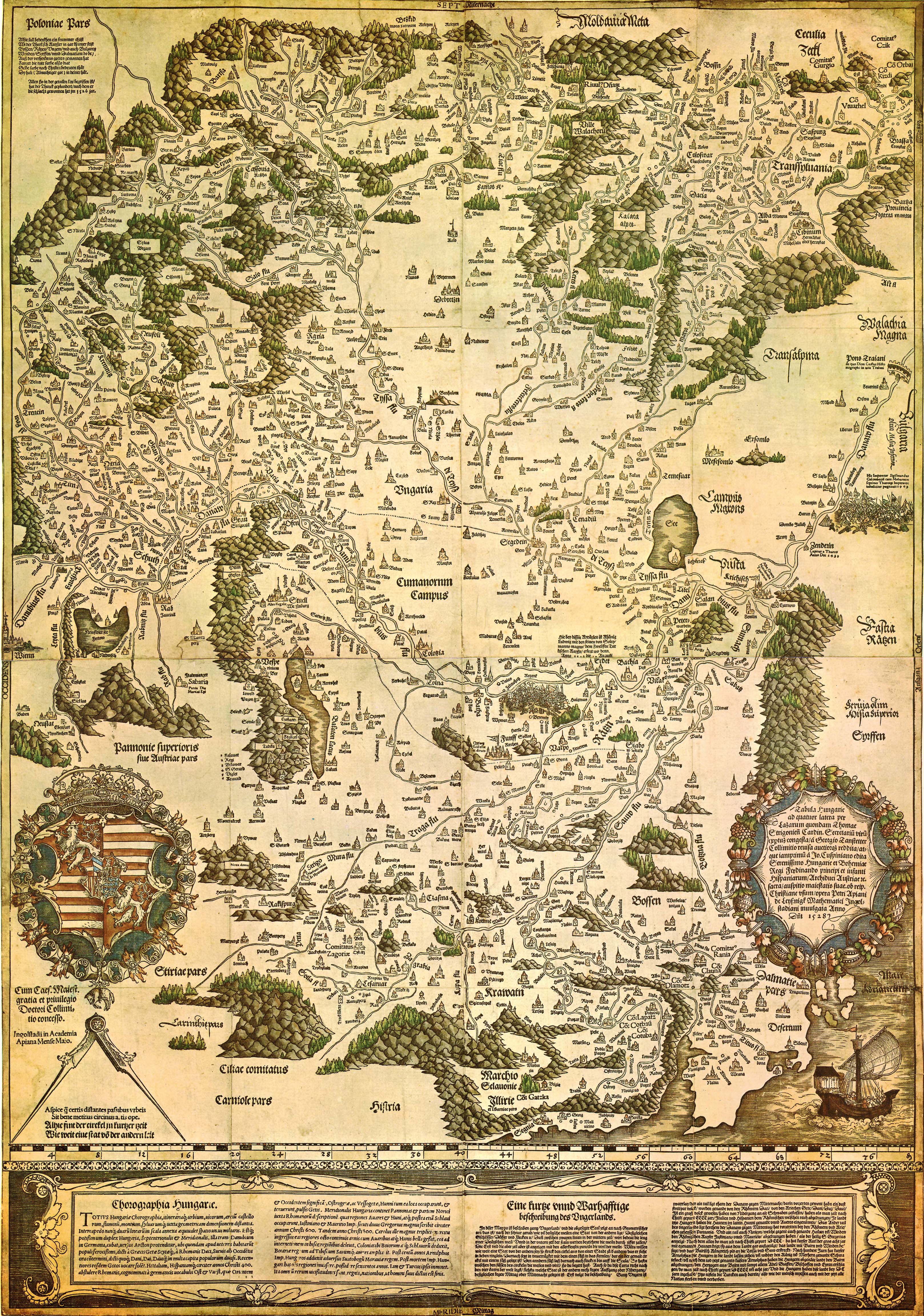
1:200000 scale maps
(redrawn) - Hungarian Kingdom, 1910 |
| 30 June 2003 |
Photos of the final exam |
| 1-5 May 2003 |
Executive Committee meeting
of the International Cartographic Association |
| 2 May 2003 |
The Department of Cartography is
50 years old |
| 21 March 2003 |
Beautiful Hungarian maps 2002 |
| 14 March 2003 |
Maps of the 3rd Military
Survey (1:200000, about 1910) |
| 2 March 2003 |
Photos of the IMTA meeting |
| 28 February 2003 |
Photos of the final exam |
| 23 February 2003 |
Hungarian topographic maps in our
Map Library |
| 16 January 2003 |
Papers of Studia Cartologica 12 |
|
|
| 25-30 November 2002 |
Béla Kovács
and László Zentai give lectures on Babes-Bolyai University
in Transylvania |
| 21 November 2002 |
PhD exam of Jesús
Reyes |
| 20 November 2002 |
Photos of GIS-day |
| 25 October 2002 |
Lazarus map (high resolution) |
| 19 October 2002 |
Photos of the final exam |
| 12 September 2002 |
Invitation to GIS
Day |
| 18 July 2002 |
Esztergom photos |
| 10 July 2002 |
Paul Fogelberg:
Atlas de Finlande 1899 - der erste Nationalatlas weltweit: eine wissenschaftliche
Leistung und ein politisches Manifest |
| 27 June 2002 |
Photos of the final exam |
| 14 June 2002 |
Photos of PhD exam
of Pődör Andrea |
4 April 2002 |
Publication of Studia Cartologica
12 |
| 22 March 2002 |
Beautiful Hungarian maps 2001 |
| 21 March 2002 |
Our mapserver with DTA-200
(1:200 000 scale digital topographic map) |
| 19 February 2002 |
Meeting of Hungis Fundation
on our department |
| 1 February 2002 |
Photos of the final exam |
|
|
| 28 December 2001 |
History of mapmaking (paintings) |
| 4 December 2001 |
Photos of Károly
Brezsnyánszky PhD exam |
| 22 November 2001 |
Photos of István
Elek PhD exam |
| 19 November 2001 |
Curriculum of the course in Cartography
from September 2001 |
| 15 November 2001 |
Open day |
| 14 November 2001 |
GIS day on our
university |
| 6 November 2001 |
Photos of Csató
Éva PhD exam |
| 25 September 2001 |
Memorial congress of Kogutowicz |
| 31 August 2001 |
Website about the
maps in Hungarian for pupils |
| 29 August 2001 |
The Hungarian winners
of ICA Barbara Petchenik competition |
| 28 August 2001 |
Mr. Viktor Orbán, the Prime
Minister of Hungary visited Mr. Klinghammer the rector of the University
in his office, on the Department of Cartography. Meeting of the Hungarian
government in Eötvös University |
| 13 August 2001 |
New photos: the webmester on the way in
China and in Finland.
New Hungarian photos (cities and villages): Eger,
Somoskő, Tar. |
| 29 June 2001 |
Photos of the final exam |
| 7 June 2001 |
Turczi Gábor PhD
exam |
| 24 March 2001 |
Opening ceremony of the "Beautiful
Hungarian Map 2000" |
| 27 January 2001 |
Open day on our department |
|
|
| 24 October 2000 |
A HUNGEO 2000 Conference
(in Hungarian) - photos and abstracts |
| 27th September 2000 |
Photos of the "Teaching
Maps for Children..." Conference |
| 18th September 2000 |
Photos of the opening ceremony
of the Millennium Map Exhibition |
| 13th September 2000 |
Publishing of the book
László Zentai: Computer cartography |
| 17th July 2000 |
Photos of Hungarian cities, areas |
| 4th July 2000 |
We have replaced our webserver |
| 3rd July 2000 |
Photos of final exams |
| 15th June 2000 |
Harkányiné Székely Zsuzsa PhD
exam
Pauer Gyula (Kentucky University,
Lexington) visits us |
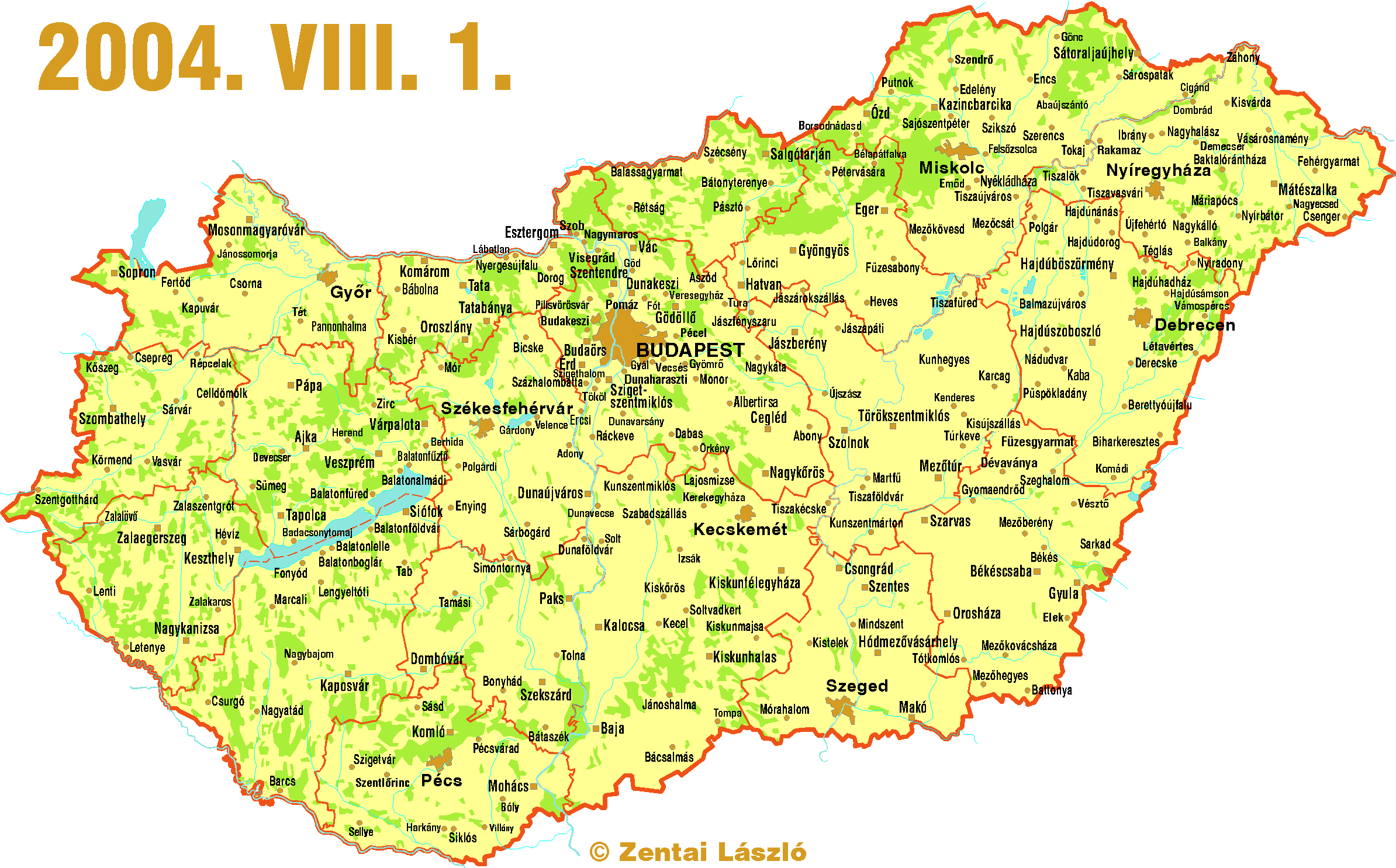
10th June 2000 |
15 new Hungarian cities, updated county
maps |
| 18th May 2000 |
Verrasztó Zoltán PhD exam |
| 4th March 2000 |
Hungarian orienteering maps,
1999 |
| 27th February 2000 |
Cartographic activities in Hungary
1995-99 |
| 7th February 2000 |
ICA CET meeting |
| 30th January 2000 |
Administrative atlas of Hungary
1914 |
| 11th January 2000 |
ISOM 2000 (www version) |
|
|
| 27th October 1999 |
Maps for environment
conference and exhibition, (photos) |
| 23th August 1999 |
Presentations of 8th ICOM |
| 29th June 1999 |
Photos of final exam |
| 17th May 1999 |
Maps for environment
conference and exhibition |
| 12th May 1999 |
New photos |
| 16nd March 1999 |
Orienteering maps (1998) |
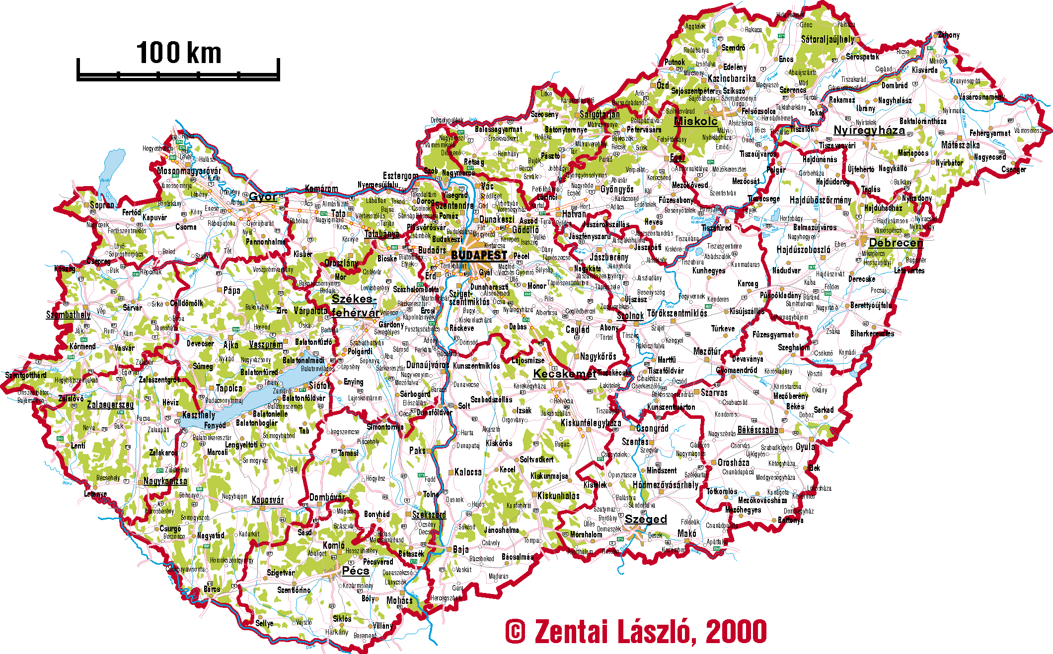
| 2nd February 1999 |
Road map of Hungary |
| 19th January 1999 |
International Workshop on
MassMediaMaps |
|
|
| 14th September 1998 |
Maps of Hungarian airports |
| 2nd September 1998 |
Maps of Austria-Hungary (1910) |
| 21st July 1998 |
Map of High Tatras |
| 29th June 1998 |
Detailed map of Hungary - Warning, the file
is large (280 kB)! |
| 4th May 1998 |
Calculating distances between
two points on the Earth (Antal Guszlev) |
| 22nd April 1998 |
Phd theses of Katalin Plihál |
| 15th February 1998 |
Eötvös University: coat
of arms - insititutes in Budapest
(map) |
| 15th February 1998 |
Map Committee of International Orienteering
Federation |
|
|
| 20th December 1997 |
Multilingual Gazetteer of
Undersea Features of the World Ocean
Details of the PhD theses of Dutkó
András |
| 30th September 1997 |
IMCoS, 16th International Symposium |
| 12th September 1997 |
Atlas of leading and 'avoidable'
causes of death in countries of Central and Eastern Europe |
| 5th September 1997 |
Mass media maps in Hungary, National report
(1997) |
| 21nd July 1997 |
News of the Hungarian Agency on Land Administration
and Mapping |
| 2nd July 1997 |
László Almásy:
The real Hungarian desert explorer |
| 16th June 1997 |
Updated list (alphabetical, by
county) and map (very large image)
of Hungarian cities. From 1st July 12 new Hungarian cities got this rank:
(Bóly, Devecser, Felsőzsolca, Gyál, Izsák, Nagyecsed,
Pilisvörösvár, Polgárdi, Sellye, Solt, Újszász,
Zalakaros). |
| 21st May 1997 |
Detailed map of Velence Hills |
| 10th March 1997 |
International Specification
for Orienteering Maps
|
| 31st January 1997 |
GIS - ISPRS |
|
|
|
|
| 8th December 1996 |
Maplists of Hungarian settlements
|
| 25th November 1996 |
Maps published in Hungary
|
| 21st October 1996 |
Maps on the Hungarian part of the Web
|
| 19th September 1996 |
Kékes, the highest point of Hungary
Summer fieldwork |
| 29th August 1996 |
New, updated county maps |
| 3rd July 1996 |
Updated list (alphabetical, by
county) and map (very large image)
of Hungarian cities. |
| 14th May 1996 |
Collection of digital maps on our server |
| 14th May 1996 |
Protected areas of Hungarian settlements |
| 15th April 1996 |
Cartographic links on Internet (tested and grouped
collection) |
| 22th March 1996 |
GIS Metadata |
| 17th March 1996 |
Publications of the webmaster
with sample images |
| 14th February 1996 |
Some new photos about our life |
| 11th February 1996 |
WWW Server statistics |
| 5th February 1996 |
Hungarian Standard Proposal - Digital
Base Map (DAT). Conceptual Model
Version 4.1 - Date of taking effect: 06. 26. 1995. - Draft! |
| 31th January 1996 |
Annual Report, 1995 - The Hungarian Agency
on Land Administration and Mapping |
| 29th January 1996 |
Description directory of the Hungarian
Geodetic Reference
|
| 29th January 1996 |
Cartographic activities in Hungary
in 1991-1995 |
 Jump to the Homepage of Department of Cartography and Geoinformatics, Eötvös University, Budapest!