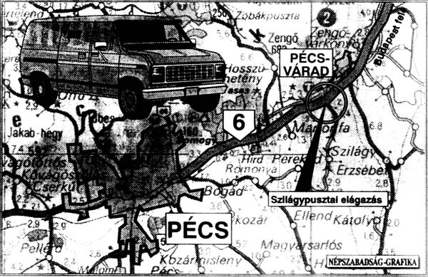
(Fig. 1.), Népszabadság 18. 01. 1997.
Historical Background
In Hungary, there is a long history of preparing media maps in various forms. Let us pick out some major points, where the Hungarian media map making largely contributed to this tradition. Most of these events are associated with the name of Professor Sándor Radó.
The first organised system of collecting data and information and presenting them in thematic map form was created by an emigrant Hungarian geographer-cartographer - but outside Hungary. This agency, "Roszta", was established as a news agency in Vienna, Austria, in 1920 and was running until 1922. The maps mainly concentrated on the boundary changes and the effects of peace treaties. The products were distributed in large copies for other publishers.
This press agency - partly serving the common newspapers by presenting map illustrations to military, political and geographic news - was reorganised or re-established in the forthcoming years. It was an enterprising supported by the Soviet Union and had several names: first it was called "Pressegeo" (or "Pressegeographie") then "Inpress", and finally, in 1936, "Geopress" - operating in Berlin, in Paris, and finally in Geneva almost until the end of the second world war.
The major step in developing mass media map production in Hungary came in the mid 1960's. There were two publications established in Budapest that time.
First, "Cartactual" was created in 1965 to support international mapping agencies with fresh map information. It was published four times a year at the beginning, the editor-in-chief being Professor Radó. Then it became a bimonthly periodical, and gradually was extended in size and modernised in execution (colours, languages, bibliographic information supplements). "Cartactual" was collecting information on new constructions (highways, reservoirs, railways) as well as geographic changes (new names, administrative divisions) from the world, and these maps were distributed (on subscription) to map publishers, libraries, universities departments or interested people all over the world until the early 1990's. In the last years "Cartactual" (editor-in-chief Ernő Csáti) was published under the auspices of the International Cartographic Association. "Cartactual" was a unique professional publication of its kind for more than 25 years. (One of the authors of the present paper worked for "Cartactual" for thirteen years).
Second, the cartographic agency, "Terra", was founded in 1966 to produce immediate geographic and political maps in one colour for the daily press in Hungary and multi-coloured insert maps for the developing TV news programmes. Róbert Suara and his staff produced hundred of maps every year to help understanding the changing world.
The political and economic changes of the end of the 1980's and the beginning of the 1990's have brought significant changes also in the field of Mass Media Cartography. For financial reasons "Terra" and "Cartactual" stopped functioning, the products of state-owned media were privatised. Maps continued to be published in the daily press but the standards have been considerably reduced.
Media cartography in Hungary has not for a long time been the subject of scientific research. The Department of Cartography of Eötvös Loránd University, Budapest - greatly inspired by Professor Scharfe and his research team - has recently undertaken scientific work in this field.
Mass Media Maps in Hungary
To demonstrate the present situation of media cartography it is necessary to survey the situation of the press, to examine the maps from the points of view of quantity and quality and to have a look at the market conditions under which the maps are being produced.
Regarding the volume of today's Hungarian press, the quantity and circulation published monthly can not be compared to the press of the developed Western-European countries, and not even to the Hungarian press itself a couple of years ago. As regards daily papers, characteristic features are the dominance of national papers and a relatively low circulation. The media market shows quickly developing tendencies in Hungary. Today, 12 significant national and 19 local so called county-papers are published daily in all together approximately a bit less then two million.
We have made an attempt to measure the number of maps published in the daily press. It is very difficult to give an exact number. The approximate number is about 500-600 maps in a year, the majority of which is published in national papers (approximately 450 and 150 in local papers). In our research we did not consider the maps appearing in advertisements and the meteorological charts.
As far as the method of layout is concerned we have found considerable differences among maps published.
Basically, we can distinguish 4 types: vector-, raster-, photo-based and photo-based with additional information. An example of this last one is presented in the next figure.
The map to be seen here - which appeared on the front page of the Hungarian daily paper of greatest circulation - raises another very interesting and peculiar problem, i. e. the problem of copyright. It can be seen in the map that its basis is a road map, which has been completed with the information in an adjacent article by a mapmaker called "Népszabadság-Grafika". The map presented does not give any reference to the origin of the base map. Unfortunately, this occurs very frequently with maps examined.
Also the quality of the examined maps shows heterogeneity. There is a universal use of the computer but occasionally we have seen maps which were apparently executed by hand.
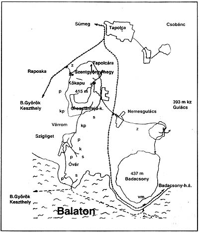
A significant proportion about 30-40 % of the maps showed technical, labelling and geographical shortcomings mostly rough-and-ready works. An example for this is the next figure.
This is also regrettable because, as it has been proved by research in Germany, the media maps are cartographic products which are available for the whole of society, moreover these are the only maps which play an educational role for a great majority of people.
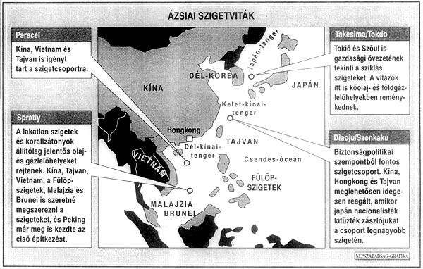
One of our colleagues at the Department of Cartography, dr. László Zentai, has opened a special page on the Web Site for the presentation of the most interesting examples. A characteristic detail of that can be seen in the following figure.
Presenting some examples like this, we aimed at improving mapmaking.
Considering the time at the makers disposal, the maps could be divided into three categories:
The Influence of the Internet on Media Cartography
The powerful expansion of the Internet which has become almost universal, has or may have among other factors great effect on Media Cartography, too. The Internet today can be regarded one of the means of public information and as such is part of what we call "Mass Media". There are two types of media products appearing on the Internet. It is a universal tendency in the world, thus also in Hungary that leading newspapers have their own Web Site where the most essential news from the printed newspapers copies are available for readers (Internet users).We are sorry to say that in the period of our observation (Jan. - Jun. 1997) no Web pages of the leading Hungarian newspapers presented maps having been published in the given paper during this period. To us this seems strange, particularly because there were such articles printed on Web Site which originally contained printed maps.
Another way of presenting media products on Internet is the "newspapers" which come out exclusively in digital form. In Hungary there are a lot of such products available through the Internet. These aiming at parts of the society do not present maps either.
Maps appearing on Internet can be theoretically divided into two categories. The first may include those which are the scanned forms, without any changes of the printed originals. These have the same characteristics as the printed press (very short time for editing and drawing, schematic way of presentation, basic labelling). The other category may include those maps which exist only in digital form. To these maps other rules apply both in the field of map making and from the point of view of "information consumption". As for map making the time of completion increases (there is no strict editorial-deadline, printing time, etc.). From the point of view of information consumption, however, there are no "short-time maps" as the consumer (mapreader) can look at the map not only for a short time. This of course influences the expectations towards mapmakers, that is cartographic presentation with more details and information. This raises the problem of copyright more clearly because these maps as every other information appearing in digital form are easy to copy, while keeping the original intact and undamaged they can be stolen.
Arriving at this point in our research a great number of such questions arose to which we were unable to give immediate answers. Only a few of these have been mentioned so far, and we wish to extend our research to the new problems in the future.
Conclusion
Hungary was present at the beginning of press cartography. It has tradition on the field of mass media maps. The political and economic changes of the end of the 1980's and the beginning of the 1990's have brought significant changes also in this field, the standards have been considerably reduced.
The Department of Cartography of Eötvös Loránd University, Budapest has recently undertaken scientific work in the field of press cartography.
The media market in Hungary is not a great one but shows quickly developing tendencies.
An important part of the maps appearing in the national press has been taken from foreign sources. As for the maps prepared locally it can be generally concluded that they are not made by professional cartographers.
Currently Hungary has no carto-agency, which could, at short notice, deliver to the printed press base and reference maps suitable for further editorial work.
The influence of Internet on the media cartography is not engaged in scientific research. In the point of view of media cartography the advantages of this media - that can be considered as a part of mass media - are not utilised properly.
 Go to the Homepage of Department of Cartography and Geoinformatics, Eötvös University, Budapest!