|
S08: Multilingual names, minority names
|
|
|
|
|
|
9. Disappearance of minority names because of plebiscites
1918-1920
|
|
|
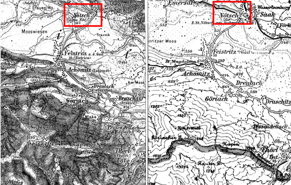
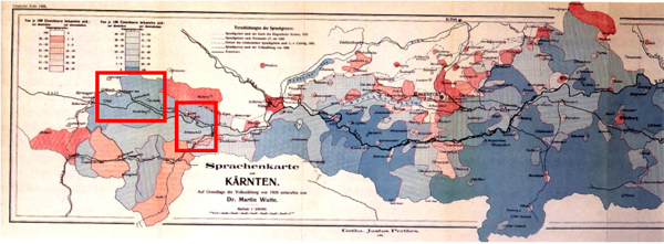
Elimination of Slovene toponyms in Austria
after the First World War. Details from the Spezialkarte 1:75
000, Tarvis, 1882 (to the left) and 1925 (to the right). From
the language map by Dr Martin Wütte (Die sprachlichen Verhältnisse
in Kärnten auf Grundlage der Volkszählung von 1900
und ihre Veränderungen im 19. Jahrhundert. Carinthia I
96, 153ff.), it can be seen that in the area depicted on the
topographic map (the right-hand red frame on the language map)
the village Nötsch (German) or Cojria Nöc (Slovene)
was located in a blue area, which denoted a majority of 81-90%
Slovene/speaking inhabitants. In 1920 a plebiscite was held
in order to determine whether the area should be part of Austria
or of Yugoslavia. 59% of the inhabitants voted for Austria,
and the Slovene names were dropped from the Austrian topographic
maps. They were retained on the Yugoslav maps of the same area,
see the G.Dravograd sheet of the series Yugoslavia 1:100 000,
1940. The area depicted on this map can be identified as the
left red frame on the language map.
Yugoslav reaction: only Slav names
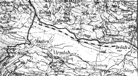
Yugoslavia, 1:100 000, G. Dravograd. 1940
|
  |
|
|
|
|
|
|
|