
8.6 Recommended symbols
All symbols from the basic orienteering map specification is applicable for the park orienteering map.
Special detail features
The larger scale of park and town maps, easily invites to additional "large scale" symbols, such as light poles, benches etc. This could be of interest for educational maps such as school maps, and as mentioned initially the map maker has to have a certain degree of freedom in this respect. However for competition maps they are of
very limited interest. As a matter of fact, the symbols defined for traditional foot-o maps covers most of the needs. If the "special features" (the "x" and "o" symbols) are used, they must always be described in the map legend.
Permanent out of bounds
In parks and cities, one can expect to find several areas that are permanently out of bounds for orienteering. Examples are planted flower beds etc that often serves as barriers (e.g. along a road) and could affect a route choice if they cannot be crossed. It can be argued that the map user should know from common sense not to pass these areas. However, for the sake of good will it is of importance to mark them on the map. The symbol 527 settlement should be used (yellow 100% / green 50%).
North lines
Park and city maps has a lot of black and therefore black north lines should be avoided.
Colour: blue. Line width 0.25 mm.
Dimensions of map symbols
Maps for park orienteering should be drawn with lines, line screens and symbol dimensions 50% greater than those used for 1:15 000 foot-orienteering maps.
8.6.2 Discipline-specific symbols
This section describes additions to and deviations from the foot-orienteering map specification.
The deviations are of two types namely deviations in cartography (symbols) and deviations in feature definitions.
Building symbols and "pass through"
Very essential features in park and town maps are buildings. Normal o-maps use 100% black to depict these, but for maps with a lot of buildings, this makes black the dominant colour, which gives a very "dull" map. A lighter tone is recommended for the buildings. Further, it is very important to get information about "pass through" possibilities in buildings. This is accomplished by an even lighter shade of grey. This creates also a possibility to depict features "under the roof".
 | 851 Building A building is shown with its ground plan so far as the scale permits. Buildings smaller than 1 mm2 on the map should be drawn with 100% black. Colour: black 50% (60 lines/cm), min 0.5 x 0.5 mm |
 | 852 Building pass-through A building pass-through means that it is possible to run through a building or under a roof or similar, without having to open doors or gates. It is shown with its ground plan so far as the scale permits. Colour: black 30% (60 lines/cm), min 0.5 x 0.5 mm |
 | 853 Building outline A black line surrounds the outline of a building or a pass-through. It may also be used to show characteristic structures or apparent height differences of a building. Colour: black. |
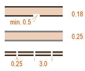 | 861 Road without car traffic Road where car traffic is not allowed, for example "walking streets" or similar. The space between the black lines must be filled with brown 30%. A road under construction may be shown with broken lines. It is possible to use 50% black/0.25 mm for the edge to better distinguish it from black man-made objects adjacent to the road. Colour: black 100% (50%) and brown 30% (60 lines/cm). |
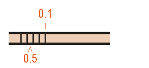 | 862 Stairways Stairways are road or track features. There should be at least two or more steps in connection and the symbol must be generalised to show at least two lines on the map. Large stairs should be drawn to exact width. Colour: black. |


