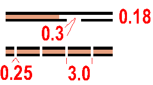
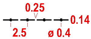
A road with two carriageways. The width of the symbol should be drawn to scale but not smaller than the minimum width. The outer boundary lines may be replaced with symbols 519, 521, 522 or 524 if a fence or wall is so close to the motorway edge that it cannot practically be shown as a separate symbol. The space between the black lines must be filled with brown (50%). A road under construction may be shown with broken lines.
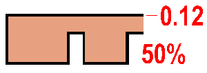
Colour: black and brown 50% (60 lines/cm).
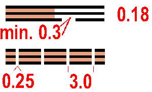
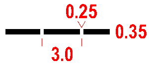
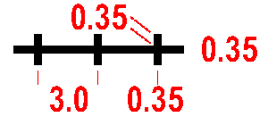
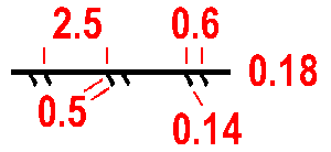
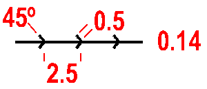
Road wider than 5m. The width of the symbol should be drawn to scale but not smaller than the minimum width. The outer boundary lines may be replaced with symbols 519, 521, 522 or 524 if a fence or wall is so close to the motorway edge that it cannot practically be shown as a separate symbol. The space between the black lines must be filled with brown (50%). A road under construction may be shown with broken lines.
Colour: black and brown 50% (60 lines/cm).
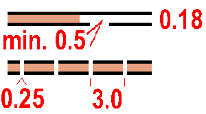
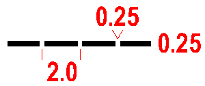
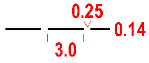
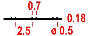
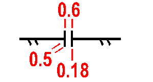
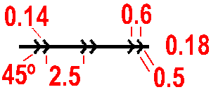
Road 3-5 m wide. The space between the black lines must be filled with brown (50%). A road under construction may be shown with broken lines.
Colour: black and brown 50% (60 lines/cm).
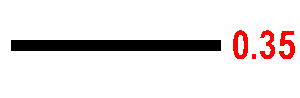
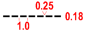
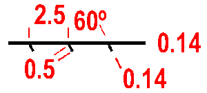
A maintained road suitable for motor vehicles in all weather. Width less than 3 m.
Colour: black.
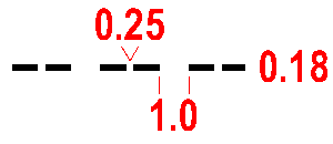
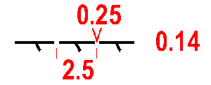
A track or poorly maintained road suitable for vehicles only when travelling slowly. Width less than 3 m.
Colour: black.
A large path, or old vehicle track, which is distinct on the ground.
Colour: black.
A small path or (temporary) forest extraction track which can be followed at competition speed.
Colour: black.
A less distinct small path or forestry extraction track.
Colour: black.
A distinct ride, less than ca. 5 m wide. A ride is a linear break in the forest (usually plantation) which does not have a distinct path along it. Where there is a path along a ride, symbols 507 or 508 should be used in place of symbol 509.
Colour: black..

When a junction or intersection of paths or tracks is visible, the dashes of the symbols are joined at the junction.
Colour: black.

When a junction or intersection of paths or tracks is not clear, the dashes of the symbols are not joined.
Colour: black.
A footbridge with no path leading to it.
Colour: black.

A path or track crossing a river, stream or ditch by a bridge.
Colour: black.
A path or track crossing a river, stream or ditch without a bridge.
Colour: black.
A railway or other kind of railed track (tramway, truckway, etc.).
Colour: black.
Power line, cableway or skilift. The bars indicate the exact location of the pylons.
Colour: black.
Major power lines should be drawn with a double line. The gap between the lines may indicate the extent of the powerline.
Colour: black.
A way under roads, railways, etc. which may be used by the runner. This symbol is used whether or not the tunnel has a track leading to it.
Colour: black.
A stone wall or stone-faced bank.
Colour: black.
A ruined stone wall may be shown by a dashed line.
Colour: black.
A stone wall higher than ca 1.5 m, not crossable to the average orienteer.
Colour: black.
A wooden or wire fence less than ca. 1.5 m high.
Colour: black.
A ruined fence may be shown with a dashed line.
Colour: black.
A boarded or wire fence higher than ca 1.5 m, not crossable to the average orienteer, eg. deer fence.
Colour: black.
All ways through or over high fences or walls must be indicated. The symbol may also be used for a gate through or stile over a stone wall (519) or a fence (522) or a pipeline (534).
Colour: black.
A building is shown with its ground plan so far as the scale permits.
Colour: black.
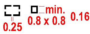
Houses and gardens and other built up areas. Roads, buildings and other significant features within a settlement must be shown. If all buildings cannot be shown, an alternative symbol (black line screen) may be used.
Colour: green 50% (60 l/cm) and yellow 100% or alternatively black 32.5% (27 l/cm).

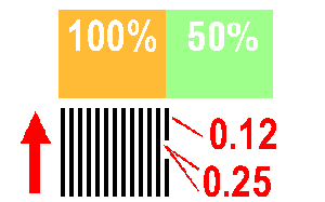
Areas which are permanently forbidden to the runner are shown as out of bounds. The screen is superimposed on the normal map detail. A bounding line may be drawn if there is no natural boundary (see 709).
Colour: black or purple 33.3% (13.3 lines/cm).
An area of hard standing used for parking or other purposes.
Colour: black and brown 50% (60 lines/cm).
The ground plan of a ruin is shown to scale, down to the minimum size shown opposite. Very small ruins may be drawn with a solid line.
Colour: black.
A firing range is shown with a special symbol to indicate the need for caution. Associated buildings are individually marked.
Colour: black.
A distinct grave marked by a stone or shrine. Location is at the centre of gravity of the symbol, which is orientated to north. A cemetery is shown by using grave symbols as space permits.
Colour: black.
A pipeline (gas, water, oil, etc.) above ground level which can be crossed over or under.
Colour: black.
A pipeline which cannot be crossed.
Colour: black.
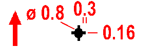
A high tower or large pylon, standing above the level of the surrounding forest. Location is at the centre of gravity of the symbol.
Colour: black.
An obvious shooting platform or seat, or small tower. Location is at the centre of gravity of the symbol.
Colour: black.
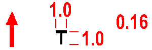
Cairn, memorial stone or boundary stone (or a trigonometric point in some countries) more than 0.5 m high.
Colour: black.
A fodder rack which is free standing or built on to a tree. Location is at the centre of gravity of the symbol. For land access reasons these may be omitted.
Colour: black.
Special man-made features are shown with these symbols. The definition of the symbols must be given in each case in the map legend.
Colour: black.


