6.6 Recommended symbols
The following symbols from the foot-orienteering map specification are recommended for the mountain bike orienteering map.
Land forms
The shape of land is shown by means of contours. In order to maintain legibility of the map with scales down to 1:30 000, when cycling at high speed the contour lines may be more generalised in comparison to foot-o maps. Form lines shall be omitted.
101 Contour, 102 Index contour, 104 Slope line, 105 Contour value, 106 Earth bank, 109 Erosion gully, 111 Knoll, 114 Depression.
Rock and boulders
Rocks and boulders are not likely to affect route choice, but where prominent they can serve as valuable features for navigation and positioning. The map may show these features when they are visible to the competitor.
201 Impassable cliff, 202 Rock pillars/cliffs, 207 Large boulder, 208 Boulder field, 209 Boulder cluster, 211 Open sandy ground, 212 Bare rock.
Water and marsh
Besides navigation and positioning, this group is important to the competitor as it facilitates the interpretation of height (what is "up" and what is "down") in maps with complex contouring.
301 Lake, 304 Uncrossable river, 305 Crossable watercourse, 306 Crossable small watercourse, 307 Minor water channel, 309 Uncrossable marsh, 310 Marsh, 314 Special water feature.
Open land and vegetation
The representation of vegetation is of importance to the competitor only for navigational purposes, not for route choices. If for example the forest is dense on one side of the path and sparse on the other, this presents navigation and positioning information. It is not necessary to grade the forest for "speed" purposes unlike maps for foot-orienteering, only for visibility. In order to meet the demands for highest possible legibility, the 30% green colour used for 406 Forest slow running has been judged optimal.
It should also be noted that the symbols 414 and 416 (cultivation boundaries) should be omitted since they may cause confusion with some of the symbols used for tracks and paths.
401 Open land, 402 Open land with scattered trees, 403 Rough open land, 404 Rough open land with scattered trees, 405 Forest: easy running, 406 Forest: slow running, 412 Orchard, 413 Vineyard, 415 Cultivated land, 418, 419,420 Special vegetation features.
Man-made features
As stated above, the track and path network provides information fundamental to the competitor. Since a new set of symbols for detailed classification of this network is introduced, the corresponding symbols used in foot-orienteering maps are omitted.
501 Motorway, 502 Major road, 503 Minor road, 515 Railway, 516 Power line, 517 Major power line, 518 Tunnel, 521 High stone wall, 524 High fence, 525 Crossing point, 526 Building, 527 Settlement, 529 Paved area, 531 Firing range, 534 Uncrossable pipeline, 535 High tower, 539,540 Special man-made features.
6.6.2 Discipline-specific symbols
The following symbols are introduced for mountain bike orienteering maps.
Road and track classification
Mountain bike orienteering requires two classifications for tracks and paths: a. speed (or "riding") and b. width. Three classes of speed and two classes of width, given in all six combinations, is optimal.
"Riding" classification
Three levels of classification is proposed: EASY, SLOW, DIFFICULT.
Width classification
Two levels of width is proposed:
 | 811 Track: easy riding A track with stabilised surface at least 1.5 m wide. Forest road or well maintained track with no obstacles. Colour: black. |
 | 812 Path: easy riding Well maintained path narrower than 1.5 m. Smooth, clean path with no erosion or obstacles. Colour: black. |
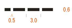 | 813 Track: slow riding A track at least 1.5 m wide. Infrequently used, with ruts, grassy, wet, muddy or sandy. Possibility of rocky surfaces. Pedalling is more difficult, riding is slowed. Colour: black. |
 | 814 Path: slow riding Path narrower than 1.5 m, through difficult terrain, with rocky or banked surface. Other characteristics as in 813. Colour: black. |
 | 815 Track: difficult to ride Rarely used track at least 1.5 m wide, with obstacles such as roots or rocky steps. Many obstacles, stones, rocks, erosion, mud, lad slides or sand. Very slow or impossible riding. Could necessitate to carry bike. Colour: black. |
 | 816 Path: difficult to ride Path narrower than 1.5 m, through very difficult terrain. Mountain paths with many obstacles. Other characteristics as in 815. Colour: black. |


