5.6 Recommended symbols
The following symbols from the foot-orienteering map specification are recommended for the ski orienteering map.
Land forms
The shape of land is shown by means of contours. In order to maintain legibility of the map when skiing at high speed the contour lines may be more generalised in comparison to foot-o maps. Form lines shall be omitted.
101 Contour, 102 Index contour, 104 Slope line, 105 Contour value, 106 Earth bank, 109 Erosion gully, 111 Knoll, 114 Depression.
Rock and boulders
Rocks and boulders are not likely to affect route choices, but in its prominent forms they can serve as valuable object for navigation and positioning. The map may show these features when they are visible to the competitor when the terrain is covered with snow.
201 Impassable cliff, 202 Rock pillars/cliffs, 206 Boulder, 207 Large boulder, 208 Boulder field, 209 Boulder cluster.
Water and marsh
Besides navigation and positioning, this group is important to the competitor as it facilitates the interpretation of height (what is "up" and what is "down") in maps with complex contouring.
301 Lake, 304 Uncrossable river, 305 Crossable watercourse, 306 Crossable small watercourse, 309 Uncross-able marsh, 310 Marsh.
Open land and vegetation
The representation of vegetation is of importance to the competitor mainly for navigational purposes, but could be used for route choices in cases where the competitor chooses to try shortcuts in free terrain. In order not to destroy legibility of the green tracks, all vegetation screens must be drawn with the symbol 406 Forest: Slow running.
401 Open land, 402 Open land with scattered trees, 403 Rough open land, 404 Rough open land with scattered trees, 405 Open forest, 406 Forest: slow running, 412 Orchard, 413 Vineyard, 414 Distinct cultivation boundary 416 Distinct vegetation boundary, 418, 419, 420 Special vegetation features.
Man-made features
501 Motorway, 502 Major road, 503 Minor road, 504 Road, 505 Vehicle track, 506 Footpath, 507 Small path (not to be seen when covered with snow), 509 Narrow ride, 515 Railway, 516 Power line, 517 Major power line, 518 Tunnel, 519 Stone wall, 521 High stone wall, 522 Fence, 524 High fence, 525 Crossing point, 526 Building, 527 Settlement, 529 Paved area, 531 Firing range, 534 Uncrossable pipeline, 535 High tower, 539, 540 Special man-made features.
5.6.2 Discipline-specific symbols
The following symbols are introduced for ski orienteering maps.
Track overprint
The track network is indicated by green symbols for track width. When a track follows a path, the green is superimposed on the path. The symbols are drawn with a compact and clearly visible shade of green (PMS 354 is recommended). Opened skiable dirt roads are shown only with black. (Roads that are cleared from snow but still skiable are only shown with black.)
If a road printed in black is not open, but has tracks on it, a track must be printed in green beside the road.
A route or road which is out-of-bounds is shown by the general symbol 711 Forbidden route, printed in purple.
All junctions and crossings must be drawn solid in order to clarify the exact position of the junction or crossing. This is valid also for dotted tracks.
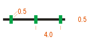
 | 801 Track >2 m Track wider than 2.0 m. Colour: green. The thinner line can be used in areas with very dense track network. | 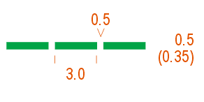 | 802 Track 1-2 m Track 1-2 m wide. Colour: green. The thinner line can be used in areas with very dense track network. |
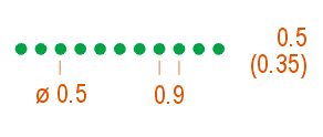 | 803 Track 0.8-1 m Narrow, soft, winding track with 0.8-1 m width. The symbols is also used for difficult slopes. Colour: green. The smaller dots can be used in areas with very dense track network. |
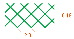
 | 804 Road covered with snow A road on the map covered with snow during the competition. The symbol is a cross line across the road. The symbol can also be used on green track symbols to show that the track is not opened. Colour: green. |
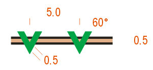 | 805 Sanded or snowless road A road on the map which is sanded or snowless during the competition is shown by a chain of V-symbols across the road. Colour: green. |
 | 806 Prepared areas Prepared slalom slopes and similar areas. Colour: green. |


