An impassable cliff, quarry or earth bank (see 106) is shown with a 0.35 mm line and downward tags showing its full extent from the top line to the foot. The tags may be omitted if space is short, eg. narrow passages between cliffs (the passage should be drawn with a width of at least 0.3 mm). The tags may extend over an area symbol representing detail immediately below the rock face. When a rock face drops straight into water making it impossible to pass under the cliff along the waters edge, the bank line is omitted or the tags should clearly extend over the bank line.
Colour: black.

In the case of unusual features such as rock pillars or massive cliffs or gigantic boulders, the rocks may be shown in plan shape without tags. Actual size may vary according to the height of the rock.
Colour: black.
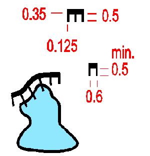
A small vertical rock face (minimum height 1m) is shown without tags. If the direction of fall of the rock face is not apparent from the contours, short tags should be drawn in the direction of the fall.
Colour: black.
Rocky pits, holes or mineshafts which may constitute a danger to the runner. Location is the centre of gravity of the symbol, which is orientated to north.
Colour: black.
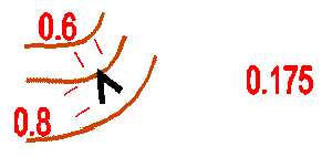
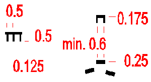
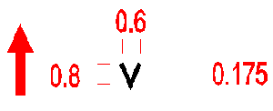
A cave is represented by the same symbol as a rocky pit. In this case the symbol should be orientated to the slope as indicated opposite. The centre of gravity of the symbol marks the opening.
Colour: black.

A small distinct boulder (minimum height 1m). Every boulder marked on the map should be immediately identifiable on the ground.
Colour: black.

A particularly large and distinct boulder.
Colour: black.

An area which is covered with so many blocks of stone that they cannot be marked individually is shown with solid non-equilateral triangles. A minimum of two triangles should be used (one only if used with other rock features). The going is indicated by the density of the triangles.
Colour: black.

A small distinct group of boulders so closely clustered together that they cannot be marked individually. The symbol is an equilateral triangle orientated to the north.
Colour: black.
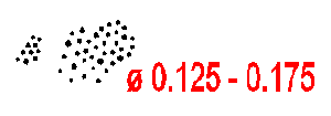
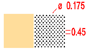
Stony or rocky ground which affects going should be shown on the map. The dots should be randomly distributed with density according to the amount of rock. For large areas a screen may be used (see table in 3.2)
Colour: black.
An area of soft sandy ground or gravel with no vegetation and where running is slow. Where an area of sandy ground is open but running is good, it is shown as open land (401/402).
Colour: black 10% (24 lines/cm) and yellow 50% (40 lines/cm).

A flat area of rock without earth or vegetation is shown as bare rock. An area of rock covered with grass, moss or other low vegetation is shown as open land (401/402).
Colour: black 30% (54 lines/cm) or grey.


