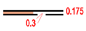
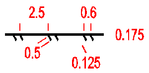
A road with two highways for the use of motor traffic only. The space between the black lines must be filled with brown (50-100%).
Colour: black and brown 50-100% (40 lines/cm).
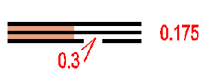
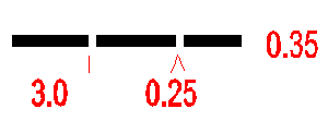
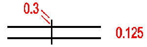
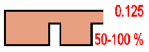
Road wider than 5 m. The space between the black lines must be filled with brown (50-100%). A road under construction ( symbols 501, 502 and 503) may be shown with broken lines.
Colour: black and brown 50-100% (40 lines/cm).
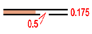
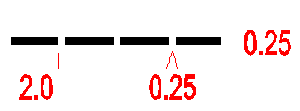
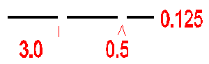
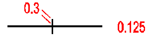
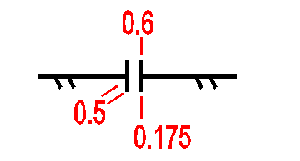
Road 3 - 5m wide. The space between the black lines must be filled with brown (50-100%).
Colour: black and brown 50-100% (40 lines/cm).
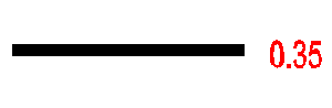
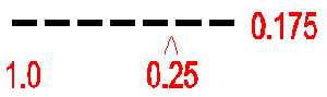
A maintained road suitable for motor vehicles in all weather less than 3 m wide.
Colour: black.
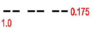
A track or poorly maintained road suitable for vehicles only when travelling slowly. Width less than ca 3 m.
Colour: black.
A large path, or old vehicle track, which is distinct on the ground.
Colour: black.
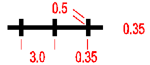
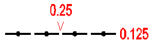
A small path or (temporary) forest extraction track which can be followed at competition speed.
Colour: black.
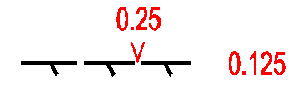
A less distinct small path or forestry extraction track.
Colour: black.
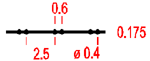
A distinct ride, less than ca. 5 m wide. A ride is a linear break in the forest (usually plantation) which does not have a distinct path along it. Where there is a path along a ride, symbols 507 or 508 should be used in place of symbol 509.
Colour: black.

When a path junction or intersection of paths or tracks is visible, the dashes of the symbols are joined at the junction.
Colour: black.
A footbridge with no path leading to it.
Colour: black.

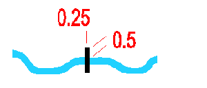
A path or track crossing a river, stream or ditch by a bridge.
A path or track crossing a river, stream or ditch without a bridge; a ford.
Colour: black.

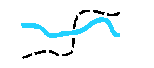
When a junction of paths or tracks is not clear, the dashes of the symbols are not joined.
Colour: black.

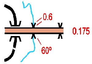
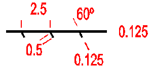
A ride or firebreak, wider than 5 m. The edges are shown with the symbol for a vegetation boundary (416). The appropriate yellow or green screen should be used to fill in between the dotted lines for open or overgrown rides respectively.
Colour: black and yellow or green.
A railway or other kind of railed track (tramway, truckway, etc.).
Colour: black.
Power line, cableway or skilift. The bars indicate the exact location of the pylons.
Colour: black.
Major power lines should be drawn with a double line.
Colour: black.
A way under roads, railways, etc. which may be used by the runner. This symbol is used whether or not the tunnel has a track leading to it.
Colour: black.
A stone wall or stone-faced bank.
Colour: black.
A ruined stone wall may be shown by a dashed line.
Colour: black.
A stone wall higher than ca 1.5 m, not crossable to the average orienteer.
Colour: black.
A wooden or wire fence less than ca. 1.5 m high.
Colour: black.
A ruined fence may be shown with a dashed line.
Colour: black.
A boarded or wire fence higher than ca 1.5 m, not crossable to the average orienteer, eg. deer fence.
Colour: black.
All ways through or over high fences or walls must be indicated. The symbol may also be used for a gate through or stile over a stone wall (520) or a fence (523).
Colour: black.

A building is shown with its ground plan so far as the scale permits.
Colour: black.
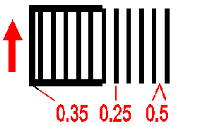
Houses and gardens and other built up areas. Roads, buildings and other significant features within a settlement must be shown. If all buildings cannot be shown an alternative symbol (black line screen 33%, 25 l/cm) may be used.
Colour: green 50% and yellow 100%.
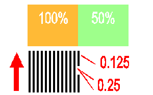
Areas which are permanently forbidden to the runner are shown as out of bounds. The screen is superimposed on the normal map detail. A bounding line may be drawn if there is no natural boundary.
Colour: black or purple.
A paved, asphalt or other surfaced area for parking or other purposes.
Colour: black and brown 50 - 100% (40 lines/cm).
The ground plan of a ruin is shown to scale, down to the minimum size shown opposite. Very small ruins may be drawn with a solid line.
Colour: black.
The plan of a sports track is shown to scale with yellow superimposed.
Colour: black with yellow and/or brown.
A firing range is shown with a special symbol to indicate the need for caution. Associated buildings are individually marked.
Colour: black.
A distinct grave marked by a stone or shrine. Location is at the centre of gravity of the symbol, which is orientated to north. A cemetery is shown by using grave symbols as space permits.
Colour: black.
A pipeline (gas, water, oil,etc.) above ground level which can be crossed over or under.
Colour: black.
A pipeline which cannot be crossed.
Colour: black.
A high tower standing above the level of the surrounding forest. Location is at the centre of gravity of the symbol.
Colour: black.
An obvious shooting platform or seat, or small tower (or a trig. point in some countries). Location is at the centre of gravity of the symbol.
Colour: black.

Cairn, memorial stone or boundary stone (or a trig. point in some countries) more than 0.5 m high.
Colour: black.
A fodder rack which is free standing or built on to a tree. Location is at the centre of gravity of the symbol. For land access reasons these may be omitted.
Colour: black.
Special man-made features are shown with these symbols. The definition of the symbols must be given in each case in the map legend.
Colour: black.


