The line widths are based on the micronorm pen sizes. All line widths and symbol dimensions must be held within 20% of their specified value. Deviations from the nominal value must only be used to improve legibility. Certain minimum dimensions must also be observed. These are based on both printing technology and the need for legibility:
MINIMUM DIMENSIONS
SCREENS
Vegetation, open areas, marshes, etc. are shown with dot or line screens. The following two tables list the permissible combinations of screens and the commercial availability of screens to meet the specifications. Some countries have produced special orienteering screens.
| s | standard commercial photographic screen |
| @ | special o-screen - available from IOF Map Committee through Harveys respectively. |
| LT | Letratone screen |
| NT | Normatone screen |
| t | line thickness |
| ø | diameter |
| s | space between centres |
| d | das length |
| g | gap |
| a | angle |
| f | fill |
| r | random dots |
| SYMBOL | 1:15000 | 1:7500 | ||||||
|---|---|---|---|---|---|---|---|---|
| Number | Colour | % | Lines | LT | NT | Dimensions | ||
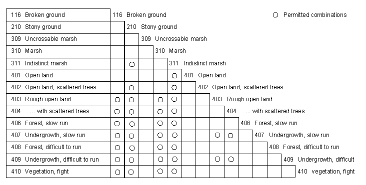
| 116 | Broken ground | brown | @ | 88 | 250 | ø0.35-0.5, r | ||
| 210 | Stony ground | black | @ | na | 251 | ø0.25-0.35, r | ||
| 211 | Sandy ground | black yellow | 10 50 | 24/cm 40/cm | s s | 8 33 | 27-10 50-50 | ø0.35, s0.9, a45° |
| 212 | Bare rock | black | 30 | 54/cm | s | 52 | 65-30 | |
| 301 | Lake infill | blue | 50-100 | 40/cm | s | 33 | 50-50 | |
| 309 | Uncrossable marsh | blue | 50 | 20/cm | @ | 213 | 1010-50 | t0.5, s1.0 |
| 310 | Marsh | blue | 33 | 27/cm | @ | 69 | 326 | t0.25, s0.75 |
| 311 | Indistinct marsh | blue | @ | 121 | 272 | t0.25, s0.85 d1.8, g0.5 | ||
| 401 | Open land | yellow | 100 | |||||
| 402 | Open with scattered trees | yellow | 42 | 12/cm | @ | na | 1160 | ø0.8,s1.2, a45° |
| 403 | Rough open | yellow | 50 | 40/cm | s | 33 | 50-50 | |
| 404 | Rough open/scattered tree | yellow +white | 50 42 | 40/cm 12/cm | s @ | 33 na | 50-50 na | ø0.8, s1.2, a45° |
| 406 | Forest: slow run | green | 20 | 40/cm | s | 30 | 50-20 | |
| 407 | Undergrowth: slow run | green | 17 | 14/cm | @ | 67 | 334 | t0.25, s1.5 |
| 408 | Forest: difficult to run | green | 50 | 40/cm | s | 33 | 50-50 | |
| 409 | Undergrowth: difficult to run | green | 33 | 27/cm | @ | 69 | 954 | t0.25, s0.75 |
| 410 | Vegetation: impassable | green | 100 | |||||
| 412 | Orchard | green yellow | 30 100 | 12/cm | @ | 911 | 315 | ø0.9,s1.6 |
| 413 | Vineyard | yellow green | 100 | @ | 353 | t0.4, s1.7, d2.6,g1.2 | ||
| 415 | Cultivated land | yellow black | 100 5 | @ | 915 | 205 | ø0.5, s1.8 | |
| 501 | Road infill | brown | 50 | 40/cm | s | 33 | 50-50 | t2.25, f1.55 |
| 502 | Road infill | brown | 50 | 40/cm | s | 33 | 50-50 | t1.7, f1.0 |
| 503 | Road infill | brown | 50 | 40/cm | s | 33 | 50-50 | t1.3,f0.6 |
| 528 | Settlement alternative | yellow +green black | 100 50 33 | 40/cm 27/cm | s s | 33 69 | 50-50 326 | t0.25,s0.75 |
| 529 | Out of bonds | black | 33 | 13/cm | s | 924 | 226 | t0.5, s1.5 |
| 530 | Parking area | brown | 50 | 40/cm | s | 33 | 50-50 | |


