Description
| Technical | Etzlaub |
Subscription-----------THE
ATLAS COLLECTUS Map SERIES
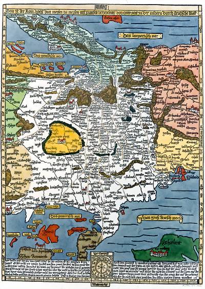
Copyright by Dr Zsolt Török, Cartart FacTsimile Publisher, 2003 (Campbell, The earliest printed maps, no.6) DESCRIPTION: The first modern road
map, the first modern map of Central-Europe.
The south oriented map shows the cities and towns in Central Europe (from Paris to Budapest) with small circles and the main rivers as well as the mountain ranges are also represented. The dotted lines indicate the major roads, the best routes from northern and eastern regions across Germany to the Eternal city, Rome. The points show distance: each dot stands for one German mile (approx. 7.5 kilometers). The first road map of the vast continental region is highly reliable. The map was specially designed to be used with the small travelling sun compas, a navigational aid shown below the map. This is why it is oriented to the south and Europe is 'upside-down' for the modern reader. From the different editions
of this once popular and useful map only ten copies have survived. There
is only one copy of the first edition, so we reproduced the original state
of this milestone map.
TECHNICAL: Technique:
relief printed from hand cut woodblock
Sheet size: 520 x 640
mm
Additional extras: On verso:
Enclosed is the relief printed
'Register'
sheet,
SUBSCRIPTION: The map is available. For more information, a free demonstrative sample of the product and/ or the Order Form please, send a message with your name and mailing address to the Publisher.
REFERENCES: Special
copy was donated to
|
|||
 The
world's only private workshop The
world's only private workshop
where the traditional map and globe making art has been revived. |
|---|
 The
RomWeg
Map, c.1500
The
RomWeg
Map, c.1500