Graphic file conversions
The conversion of graphic information is not a simple process. Sometimes the
graphic information is stored in one file (general graphic software). Other application
(CAD, GIS) tend to use a group of files to store graphical information to be able
to maintain the special connection between graphic elements and other information
(database connection, object libraries).
The two main type of the graphic information are the raster and the vector. The
conversion within the main groups looks simpler, but it can be very complicated.
1. Conversion between raster formats:
The structure of raster images is always the same: the pixels build up a file,
like a matrix. Each pixel has its own attribute (black/white, greyscale, colour).
We have only two things to take into account:
- In some formats there are special limits (file size, colour depth, lossy compression).
| The original photo (24 bit colour depth) |
 |
| The number of colours os limited to 64. |
 |
| The number of colours os limited to 16. |
 |
- If we convert from a sophisticated raster format to a simple one we can loose
the extra features (geographic coordinates and/or projection information in GeoTIFF
or raster layers in other formats, like Adobe Photoshop).
2. Conversion between vector formats:
Most of the vector formats of the different application are very sophisticated.
The most we can get is the conversion of the location (coordinates) of graphic
elements (point, line, area). We can loose the graphic attributes (line width,
line style, special fills, point symbols). The general graphic softwares use Bézier-curves,
but this kind of feature is not available in GIS environment.
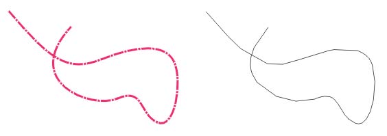
The original Bézier-curve has lost several attributes after the conversion.
[Table of contents] [Next]
Suggestions are welcome
zetor@ludens.elte.hu