| CHINA
REGNUM,
Antwerp
1593
|
|
ORIGINAL
TECHNOLOGY- Limited Edition!
Subscription:
Some
colored copies are available.
For more information,
a free demonstrative sample
of the product and/or Order please,
send a message with your name and mailing address
to
the Publisher.
The
China Regnum Cartart FacTsimile 2002 edition is
dedicated
to: Cornelis de Jode of
Antwerp
and
Steven R. Carroll
map
collector
and friend in Beijing
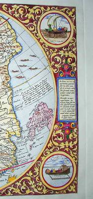
The famous Chinese 'windaggon' (wind
cart)
|
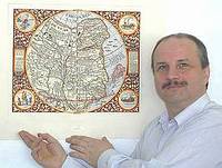
The
cornerstone of any oriental map collection, one of the rarest and most
decorative early maps of China, Japan and and the Far East from the
rare,
1593 atlas by Cornelis de Jode.
Total edition is
limited to 99 copies!
Makes an outstanding
decorative addition to the office or home and superb corporate gift to
mark special events.
TECHNICAL
Information:
Edition
limited
to 99 copies.
Printing
plate:
hand
engraved and etched original copper plate!
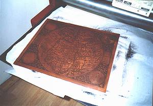
Printing
technique:
intaglio.
Copies
are printed by the Publisher.
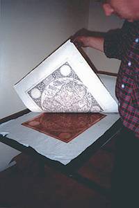
Paper:
custom produced hand made paper,
acid free, archival quality,
deckle edged
Watermark:
two OT- diagrams
and 'cartart' label legible. Can not be removed.
Sheet
size: c. 520 x
640 mm
Image
size: c. 340 x
450 mm
Color:
hand colored
in contemporary style
Copies are individually
numbered and blind stamped.
Custom coloring is available
to request.
Note:
images
have been slightly distorted for security reasons.
The order
of the roundels has been changed. See the wind
wagon in the upper
right corner on the 2002 edition!
up 
|
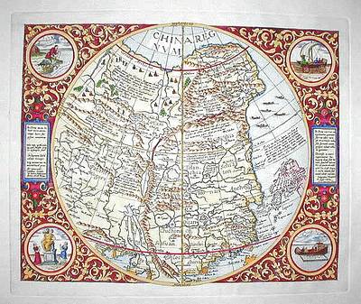
DESCRIPTION of the
map:
A
rare and distinctive map that first appeared
in Cornelis de Jode's Speculum
Orbis Terrae, (Antwerp, 1593).
This
first edition of the atlas was issued by Cornelis de Jode's
father,
Gerard in 1578, in competition to the work of Abraham Ortelius. The
second
edition was published by the widow and the son, Cornelis de Jode as
Speculum
Orbis Terrae in 1593.
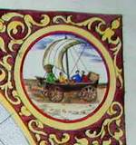
The
elaborate strap work border has four
round insets showing European visions of Chinese
and Japanese
scenes: fish catching cormorants; a Chinese junk with a chimney topped
cabin and fenced in area on the side of the vessel sheltering domestic
birds and fowl; a Japanese worshipping a triple headed deity; and the
most
famous wind wagons depicted on many early European maps of the region
including
those of Hondius and Speed. The
illustrations on De Jode's map pre-date the famous illustrations found
in de Bry's Grands et Petits Voyages and most likely derive from
contemporary
Jesuit reports. They provide some of the earliest detailed Western
illustrations
of any aspect of Chinese and Japanese life.
A
central circle encloses a map
of China,
Northeast Asia and parts of western Japan including Kyushu, Shikoku,
and
most of mainland Honshu. The emergent shape of the Korean peninsula and
Gulf of Pecheli (Bohai) are firsts on a European map. Note
the over-sized
representation of the Pearl River Estuary (perhaps reflecting its
importance
in trade). It is unusually well detailed: Guangzhou, Macau,
Sancian
(Shangquan Dao near Taishan in Guangdong) and other places are
identified.
 The
shape of China began to take
definite, if inexact, shape in the 16th
century, due primarily to the voyages of Portuguese traders and Jesuit
missionaries. This map first appeared in the 1593 edition of de Jode's
world atlas, the Speculum Orbis Terrarum. It was based on the work of
the
Portuguese Jorge de Barbuda, whose The
shape of China began to take
definite, if inexact, shape in the 16th
century, due primarily to the voyages of Portuguese traders and Jesuit
missionaries. This map first appeared in the 1593 edition of de Jode's
world atlas, the Speculum Orbis Terrarum. It was based on the work of
the
Portuguese Jorge de Barbuda, whose
map
of China appeared in the work of de Jode's
competitor Ortelius in 1584.
CORNELIS
DE JODE
(1568-1600) was the son of the map maker and publisher
Gerard de Jode ( c. 1509-91), born in Nijmegen, was a cartographer,
engraver,
printer and publisher in Antwerp. The publisher issued maps from 1555
more
or less in the same period as Ortelius. He was never able to
offer
very serious competition to his business rival, although, ironically,
he
published Ortelius' famous 8-sheet World Map in 1564.
His major atlas,
Speculum orbis
terrarum, now extremely rare, could not be published until 1578, eight
years after the Theatrum, Ortelius having obtained a monopoly for that
period. The enlarged re-issue by his son in 1593 is more frequently
found.
On the death of Cornelis, the copper plates passed to J. B. Vrients and
apparently no further issue of the atlas was published. De Jode maps
are
rarely found in the map market.
up
REFERENCES:
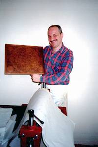
See the
image of the Presidential copy
No. 1
:
The special
presentation copy
was engraved, printed, colored and gilt
Dr. Zsolt
Török's
unique Cartart
workshop in Hungary.
Reviving
the traditional art of map and globe making
up
|

 The
world's only private workshop
The
world's only private workshop