Orienteering was practised in our Country by Military, whom used to do for military purposes.
The Military did championship almost every year, with military maps.
In 1992, 4 Officers and 3 Non- commissioned Officers went to the 25th C.I.S.M. World Orienteering Championship, in Brasil.
In 1993, the world wide Orienteering Promotion offers to Uruguay support to develop the sport in our Country.
In December 02- 06, 1996, we had a Clinic about Maps and Orienteering routes.
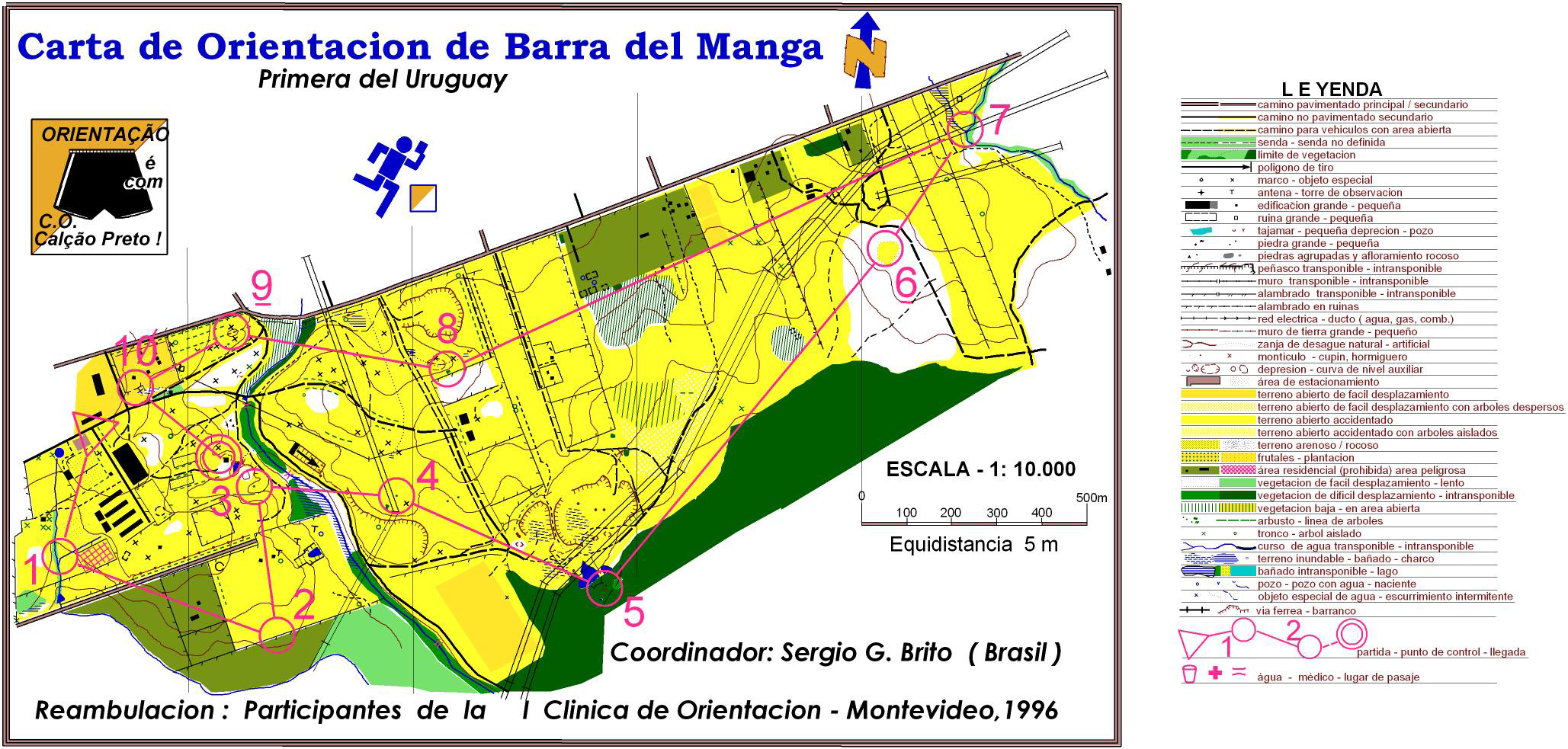
It was brought by Major Sergio Brito, from Brazil, who did the map Barra del Manga for orienteering purpose.
In December 8, 1996, came to Uruguay, sent by the World Wide Orienteering Promotion, Sivert Axelsson and Ulf Ericson, and they did the Fortin de Santa Rosa map.
In January 3, 1997, we had the first Orienteering competition with that map, with the participation of runners from Sweden, Norway, Finland, Spain, Germany, Argentina and Uruguay.
The first day of March, 1997, born the Asociación Uruguaya de Orientación, with the purpose of develops the Orienteering in Uruguay.
In April 27, 1997, we did the 2nd Orienteering Competition in Barra del Manga with 44 runners in two category, Open and Beginners.
In June 8, 1997, was the 3rd Orienteering Competition in Barra del Manga with more than 30 runners in that two category.
In July 8, one Army Unit, the Branch and Service School, did the Sargento Francisco de los Santos Orienteering Competition according IOF rules in the Fortin de Santa Rosa map, with 28 runners.
In August 30, 1997, started the first Official Championship organised by the Asociación Uruguaya de Orientación, with the sponsor of the Sweden Official Attaché and with the presence of the Tourist Ministry. It was the Preparation Championship, in the Fortin de Santa Rosa map.
In November 30, 1997, we did the first Orienteering National Championship, into the 3rd Games Uruguayan Sport Confederation, with one map done for this event in the Ranch María Celia, in the region Rincón de Burgos.
In March 14, 1998, was the First Anniversary Competition, in the Fortín de Santa Rosa map.
During the months of May and August, 1998, were the two stages of the Preparation Championship, in Parador Tajes (military map, scale 1/ 12500) and in the Fortín de Santa Rosa map.
In November 27,1998, we organised the First MERCOSUR countries Orienteering Championship, Independence of Brazil Cup, with the participation of runners from Argentina, Brazil, Norway, Belgium and Uruguay.
Runners representing our Association, take part of the 3rdand 4th Stages of the Campeonato Gaúcho de Orientación, Brazil.
In November 1st, 1998, was the First South America Meeting, in the City of Rivera, Uruguay, and City of Santana do Livramento, Brazil, joint with the 5th Stage of the Campeonato Gaúcho de Orientación, and simultaneous for the National Orienteering Championship.
Between December 2 and 5, 1998, was done in the Colonia, one Orienteering Clinic for Beginners, to develop the sport, with the participation of students from the Secondary School, and teenagers in general. It was sponsored by the Tourist Office of the Council of the City of Colonia, and the 2nd Infantry Brigade.
At the end of this Clinic, was the First Colonia del Sacramento Competition, on December 6, with the participation of 64 runners with wide range of age in both sex.
Finally, between 18 and 20, January 1999, we received the visit of one I.O.F.
Council Member, Higino Esteves, who did a clinic to develop our sport and help
us about how to maintain and develop the Orienteering in Uruguay.
The first o-map of Uruguay (thanks to Colonel Sérgio Brito):