Teaching Cartography across the Web in Hungary
Jesús Reyes Nunez
Dept. of Cartography. "Eötvös Loránd" University.
1. "Sulinet" programme.
This programme, officially patronised by the Hungarian Ministry of Education,
began on the 1st of September of 1996. The principal purpose of Sulinet was to
connect all the secondary schools of Hungary to Internet. The date for the
completion of this programme was September of 1998.
 In the first
phase of the programme, which lasted until early 1998, altogether 743 secondary
schools were equipped with 6 to 16 computers, depending on the number of pupils in the school. In the second phase, which was finished in September of
1998, the rest of the schools received uniformly 8 computers.
In the first
phase of the programme, which lasted until early 1998, altogether 743 secondary
schools were equipped with 6 to 16 computers, depending on the number of pupils in the school. In the second phase, which was finished in September of
1998, the rest of the schools received uniformly 8 computers.
The Ministry of Education worked simultaneously in two sub-programmes: one of them
provided instructions for teachers about the use of computers, while the other
sub-programme promoted the design of Homepages in Hungarian language, and gave
special attention to its thematic content for pupils in secondary schools.
We can have an idea about the importance of this programme if we read the results
of the studies that the Ministry of Education made: at present, more than 100
thousand children and their teachers relatively frequently use the opportunity of
surfing across Internet. The preferred hours for surfing are between 8:00 a.m. and
6:00 p.m. During this period, the schools receive three times more data through
the international lines than they send to other countries.
Originally, this programme intended to include also the connection of all the
Hungarian elementary schools to Internet at the latest by 2002. In September of
1998, the substitution of the "Sulinet" programme was declared by a new programme
from 1999 onwards: Írisz, with the principal object of developing the needed
content to make the investment of the past two years really useful for the
 education. This means that the Ministry has placed the financial assistance to
the extensive increasing of the network to the second place. During the two last years more than 300 elementary schools were connected to the Web. In the
forthcoming years, the connection of the elementary schools will depend not only
on the Ministry, but also on different Hungarian and international foundations.
education. This means that the Ministry has placed the financial assistance to
the extensive increasing of the network to the second place. During the two last years more than 300 elementary schools were connected to the Web. In the
forthcoming years, the connection of the elementary schools will depend not only
on the Ministry, but also on different Hungarian and international foundations.
At present, the principal obstacles to satisfying the pupils' needs and exploiting
at most the possibilities of the Web in the connected schools are as follows:
- The number of computers in a school does not satisfy the demands of the pupils.
For this reason the majority of the pupils have not the chance of daily access to
Internet.
- The teachers' education of computer use is beginning only now. There is no
qualified system administrator in each school, who would have the needed knowledge
and experience to carry out this task.
- The teachers are afraid of computers, partly because some of the pupils are more
"mixed" with the new technology than the teachers themselves.
- The actual content in the Web of the subjects taught according to the Educational
System in Hungary and written in Hungarian is not yet satisfactory. In some subjects
(for example, in geography there is only one Homepage) there is nothing officially
registered in the Web.
This is the present state (December of 1998) of the spread of Web in the elementary
and secondary schools in Hungary. Utilizing the interest of the government in the
promotion of the use of WWW within the scope of teaching, I decided to create a
Homepage to present cartographic concepts for children in a different way, adapting
and complementing these concepts in accordance with the new possibilities offered
by Internet.
2. Cartography for children in the Web.
My first work in this theme dates from 1997, when I prepared a "digital" presentation
to complement the cartographic knowledge acquired by children in the subject
"Protection of the Environment".
After some initial meetings with teachers of Elementary Schools I began to think
what kind of themes could be interesting for children and at the same time to
prepare a general draft about the wide fields comprehended within Cartography.
The content was divided into five principal themes, including the following points:
1. Presentation of the Earth.
(Earth , Moon and nearest planets)
2. History of Maps.
2.1. Ideas about the shape of the Earth in the ancient civilisations.
2.2. The Babylonian World Map.
2.3. Maps from different regions of the world (Japan, Mexico and Italy).
2.4. Discovery of America: Juan de la Cosa's World Map.
2.5. The first Hungarian map (Lázár Deák, 1528).
3. Sources of actual maps.
3.1. Theodolite.
3.2. Aerial photographs.
3.3. Mapping satellites.
3.4. Space Images.
3.5. GPS.
4. Principal elements of the maps.
4.1. Scale and graphic scale.
4.2. Geographic Co-ordinate System (projections).
4.3. Colours.
4.4. Symbols.
4.5. Geographic names.
5. Digital Cartography.
5.1. Remote Sensing.
5.2. Digital maps (animated maps and atlases).
5.3. Maps and data (GIS).
5.4. Three-dimensional models.
5.5. Virtual Reality.
5.6. Maps and Internet.
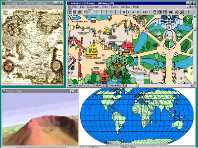
In all, during the lecture I used:
- 37 images
- 4 videos
- 2 digital atlases (Hungarian Electronic World Atlas and Demo of the Centennial Historical Atlas)
- 2 shareware programs (LViewPro, VMPEG)
- Adobe Acrobat Reader (presentation of DisneyWorld in .PDF format)
- MapInfo 3.0
- Different WWW Home Pages.
The result is a Homepage which sums up the principal map concepts for pupils of
elementary schools in Hungary. This material constituted only a little initial
step to create a more didactic and interactive Homepage, with all the necessary
themes to complement the concepts we can find in Hungarian textbooks and to
introduce children in a deeper (and I hope more interesting) knowledge of Cartography.
In the last three years I was having contacts with the geography teachers of
Hungarian elementary and secondary schools to know their opinions and suggestions
about this theme. With their help I could access to the literature they use in
their classes, including text- and workbooks, curriculums, methodological guides,
etc.
Based on my investigations, I must lay the major emphasis on the explanation and
completion of cartographic concepts for children between 3rd and 6th grades
(from an age of 8 to 11 years). In these four years the pupils receive the most
important lessons about using and reading maps. The preliminary list of
"obligatory" themes is:
- Orienteering with/without maps in nature.
- Map and reality.
- Scale and graphic scale.
- Colours.
- Symbols.
- Geographic names.
- Political and geographic maps.
- Geographic Coordinate System: latitude and longitude.
- Simple measuring on maps.
+1: Locating of places on a globe and on a map.
The first six themes are learnt by the children in 3rd and 4th grades, the rest
in 5th and 6th grades. The "Locating of places on a globe and on a map" is taught
for children in 8th grade, when they receive the first notions about trigonometry.
The following point in my preliminary investigations was determining exactly the
concepts to be presented in each of the eleven themes. Of course, the starting
point was the content of the text- and workbooks, but the completion of the
concepts was an other important task. As an example, I list two of the topics
with the principal concepts below:
- Orienteering with/without maps in nature.
. Cardinal points.
. What is the compass?
. How can we use the compass?
. Orientating maps with a compass and a watch.
. Orienteering according to the Sun.
. Orienteering in the wood.
- Scale of the maps.
. What is the scale?
. Reading the scale.
. Graphic scale.
. Large and small scale maps.
Before the decision of the structure of the Homepage, I visited a lot of sites
in the Web related to Cartography for children and other related sciences (this
list will be included in the section dedicated to links in the Web). The purpose
of these visits was the consultation of different points of views about how we can
present scientific topics for the children and young people. Parallel to this, I
looked up some papers and works, which describe the appropriate graphic and oral
language for the communication with children from a pedagogical angle. Joining it
with my original ideas sprung up the following structure, which divides the
Homepage in seven principal sections:
- Summing up
For the presentation of previous works related to this theme.
- As you are learning and even more
This is the kernel of the Homepage: in this section we can find the basic concepts
about Cartography and its completion.
- Try out!
Demos, examples, etc. that I have found in Homepages along the World.
- News and events.
Information about activities related to Cartography: organization of exhibitions,
meetings, interests on TV-programmes, news about the CCWG, Barbara Petchenik-Award,
etc.
- Not only for you
but for teachers too!
Open forum for the exchange of opinions, questions, suggestions, etc. It is
possible to include a section with tips and hints for the teachers, to deepen some
topics presented in the second section.
- Learn and play!
Presentation of tasks and games related to Cartography. These could be computer-
or traditional games that can be played on a computer or with their friends (at
home, in a park, etc.).
This Homepage will be under "permanent" renovation, offering new demos, graphic
applications, etc. We want to dedicate special attention to the section for the
teachers, which will be updated with their opinions and questions. We trust in the
success of the active cooperation of the teachers to obtain others cartographic
materials and to keep it up-to-date. This teamwork must result in a Homepage that
can contribute to enhance the quality of teaching and to enhance the interest of
the pupils in Cartography.
 Vissza a szerző honlapjára!
 Vissza a Térképtudományi Tanszék kezdõlapjára!