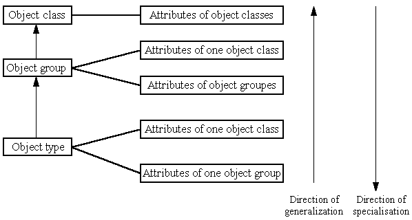
The hierarchical structure of this is shown on this figure:
The objects can be classified by grouping according to their features. To the individual classification levels - inclusive of the level of the object, too -can attributes and relationships be attached, which describe the features of the objects, things of the real world essential from the point of view of DAT in form of data.
In the database DAT the following classification levels are used:
Each of the levels has a name and a code:
| A | TECHNICAL FRAMEWORK MAP | |
| AA | HORIZONTAL AND 3D GEODETIC CONTROL POINTS | |
| AB | VERTICAL GEODETIC CONTROL POINTS | |
| AC | DETAIL POINTS | |
| AD | PUBLIC ADMINISTRATION UNITS | |
| AE | PUBLIC ADMINISTRATION SUBUNITS | |
| B | PARCELS | |
| BA | PUBLIC DOMAIN PARCELS | |
| BB | NOT PUBLIC DOMAIN PARCELS | |
| BC | SUBPARCELS | |
| C | BUILDINGS, FENCES AND TERRAIN FEATURES | |
| CA | BUILDINGS (also those classifiable into the classes of object D, E, F) | |
| CB | ACCESSORIES OF BUILDINGS (accessories of object types of the CA) | |
| CC | FENCES AND SUSTAINING WALLS (also those can classifiable into the classes of object D, E, F) | |
| CD | TERRAIN FEATURES | |
| D | TRANSPORTATION FACILITIES | |
| DA | IDENTIFICATION POINTS OF TRANSPORTATION FACILITIES | |
| DB | TRANSPORTATION FACILITIES OF INHABITED AREA | |
| DC | ROADS (RURAL AREA) | |
| DD | RAILWAYS AND TRAILS OPERATED WITH ELECTRICITY | |
| DE | FACILITIES OF AIR TRAFFIC | |
| DF | TECHNICAL OBJECT OF THE TRANSPORTATION | |
| E | CONDUITS, CABLEWAYS | |
| EA | AXIS OF CONDUITS, CABLEWAYS | |
| EB | TECHNICAL OBJECTS OF CONDUITS, CABLEWAYS | |
| F | WATERS AND HYDROLOGICAL FACILITIES | |
| FA | FLOWING AND STILL WATERS | |
| FB | WATER PUBLIC UTILITIES | |
| FC | HYDROLOGICAL TECHNICAL OBJECTS | |
| G | RELIEF | |
| GA | CONTOUR LINES | |
| GB | RELIEF CONFIGURATIONS | |
| GC | DIGITAL TERRAIN MODEL | |
| H | BOUNDARIES | |
| HA | BOUNDARIES OF LAND USE CATEGORIES | |
| HB | BOUNDARIES OF QUALITY CLASSES OF ARABLE LAND | |
| HC | SURVEY AND DAT REGISTRATION CIRCUITS | |
| HD | BOUNDARIES OF SPECIAL INTEREST OR DERIVED BOUNDARIES | |
| . | . | |


 Jump to the Homepage of Department of Cartography and Geoinformatics, Eötvös University, Budapest!