13. representation of boundaries on maps
Boundaries of natural regions:
By having a source with these boundaries, cartographers will know where to put the names of the named feature.
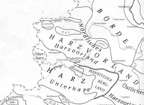
(Übersicht der Landschaften, Gebirge, Höhenzüge und Niederungen vom Staatsgebiet der Deutschen Demokratischen Republik. Berlin 1980.)
For boundaries of seas and oceans we have sources like this:
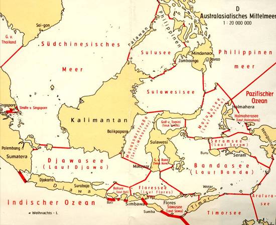
(Die Grenzen der Ozeane und ihren Nebenmeere. Seehydrographischer Dienst DDR. Weltkarte, Equatorialmassstab 1:45 Million. Namen und nautische Grenzen der Ozeane und Meere. Blatt 5001. VEB Hermann Haack. Petermann's Geographiasche Mitteilungen 114, 1970-4)
Homework
Describe with the help of an atlas within which sea area (bounded by which islands) the names "Strait Macassar" (Makassar strasse) and "Celebes Sea" (Sulawesi Sea) should be portioned!
(Celebes Sea is bounded by Mindanao, the islands between Mindanao and Celebes /Sulawesi/, the shortest connection between Celebes and Borneo /Kalimantan/ and the islands between Borneo and Mindanao)
|
|
||
|
|
|
|
Home
|
Selfstudy
|
S5:
Fieldwork