|
|
Final Report
The
conference was
organized by Eötvös
Loránd University,
Budapest,
with the support of the Hungarian Society for Geodesy, cartography and
Remote Sensing and in cooperation with Imago
Mundi Ltd.
London. ICHC 2005 took place
in
Budapest,
Hungary and was run from Sunday, July
17
to Friday, July 22, 2005.
Working
sessions
were held in the Northern Building on the
Lágymányos
campus of the Eötvös
Loránd University.
ICHC
2005 co-ordinator was Dr. Zsolt
Török,
assisted by Ms.
Krisztina Irás
as secretary of the ICHC 2005 Academic Secretariat.
Registration,
accomodation, travel and logistics was arranged by the Mrs. Ilona Módli
and her
Conference Secretariat staff at Aktiv Tours Kft..
The academic programme was
organized with the support of the Academic
Programme Committee, headed by Prof.
István
Klinghammer, Rector of the
Eötvös University. Special thanks to Tony Campbell, Chairman of Imago
Mundi Ltd. and the IM Directors who contributed to the Budapest
conference.
197 participants attended
the conference (USA:
45, UK: 16, Hungary: 20,
European Union: 103 people), with 42 accompanying
persons, the
total
number of conference participants is 235 (not including the
organizing
staff members), which is a new European ICHC record (more on ICHC
statistics).
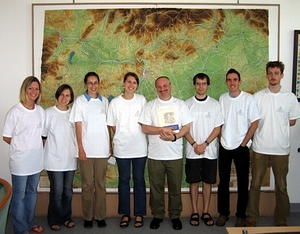
ICHC
2005 Staff (with volunteer students,
from left): Szilvia
Bobák, Eszter Dombóvári,
Nóra Valyon, Krisztina Irás, Zsolt
Török, Gergely
Somogyi, Nyerges János,
János Balázs, Katalin Bite
(was absent)
The
overriding conference theme was Changing
Borders, other conference
themes were (1) mapping the Habsburg Empire, (2) the history of
military mapping, (3) Old World - New Worlds, and (4) any other aspect
of the history of cartography.
In
addition
to the stated conference
themes, the organisers have decided to invite proposals for papers that
make central reference to the inspiration provided by the ideas and
methodologies
of Prof. David Woodward.
The papers and poster in the
programme were
selected by
the ICHC 2005 International Paper
Selection Committee, chaired by Prof. Roger Kain (see
more).
The presentations
were organized into 21 sessions, including two
discussion sessions (The History of Cartography Project, and Promoting
the Use of Historic Maps in Schools), altogether 60 papers were
presented (including one voice PowerPoint paper). On July 19 we had the
traditional Poster Day, with no concurrent sessions, in the Harmony
Hall. A total of 34 posters were presented.
Thank you for the contributors, we are especially grateful to the session Chairs (listed in the programme) for their excellent work!
The abstracts of the papers and posters, with a short curriculum vitae
of the presenter(s) (and some illustrations) were published in English
in the printed program, 'Changing Borders'.
(For a free copy of the
volume please, contact the ICHC 2005 co-ordinator.)
The special workshops organized for
groups of conference participants
were:
- Early Map Printing Workshop,
organized by
Zsolt Török (Gastaldi
copper plate printing) and George Carhart (Ramusio: wood block
printing, video presentation arranged by Béla
Kovács, printing with the
help of József Szekerka). The ICHC 2005 conference map was a
new
edition of the oval world map of the Gastaldi Ptolemy (Venice, 1546),
engraved into coper by Zsolt Török. Workshop
participants could print
their own copy (more)
- Plane Table Topographic Survey,
organized
by Zsuzsa Draskovits,
Zsolt Török, László Buga.
Participants in the two morning groups were
instructed by Zsuzsa Draskovits, Zsolt Török,
József Szekerka, as well
as our guest-instructors: Alexey Postnikov and Peter Collier.
Three
map exhibitions were prepared in conjunction with the
conference:
- "Margaritae Cartographicae:
Treasures of
the National Library" at the National Széchényi
Library.
- "Earth and Sky: Astronomy and
Geography at
the University" at the Eötvös University Library.
- "Military maps in Hungary from
the 16th to
the 20th century" at the Military Historical Institute and Museum.
Receptions:
After
the opening of ICHC 2005 and following the special exhibitions
participants and guest were invited for refreshments and snacks. We are
grateful for the support received from our sponsors, whose
generousity made these receptions possible: the Office of the Minister
President, Republic of Hungary, The Columbia Gazetteer of the World-
Online, Mr. Tamás Korányi map collector and the
host institutions.
The standing commission on the History of Cartography of the
International
Cartographic Association (ICA) was held on 19 July,
chaired by Prof. Alexey Postnikov. This morning there was a special
presentation on the history of maps of Iran, delivered by Mr. Mohammed
Sahab.
On Saturday, July 16, the International
Society of Curators of Early
Maps held its biennial meeting during a special tour in the
town of
Kalocsa, combined with a tour and visit of the Archdiocesan Library.
(more)
After the conference there was a special Blue Danube Post
Conference Tour, organized for participants. Visits included
the Pannonhalma
Benedictine Archabbey (map exhibition "Sacred Places on Maps"), the
Vienna Historical Museum, The Map Collection, Austrian National
Library, (Vienna), The Danube Museum (Esztergom).
The Farewell dinner was held at Lazar Equestrian Park,
Gödöllö (96 people participated).
The final ICHC 2005 conference
programme can be downloaded from the
conference web site.
Conference
publications:
- Zsolt Török,
Krisztina Irás
(eds.): Changing
Borders. Programme, Absrtracts of Papers and Posters, Curricula Vitae,
and List of Participants.
ICHC 2005 Academic Secretariat, Budapest, 2005, 157 p.
- Cartographica
Hungarica,
No. 9, 2005.
július, Térképtörténeti
magazin- Magazine for Map History (Balatonkenese
: Szathmáry Tibor),
Különszám- Special Issue. 28 p. The
special
conference issueof the private magazine included the summaries of
the articles
published in Cartographica Hungarica (1992-2004) in English and in
Hungarian, the Indexes and a short history of Hungarian
cartography.
- Facsimile
map: Johannes
Korabinsky:
Novissima Regni Hungariae potamographica et telluris productum Tabula-
Wasser und Producten Karte der Koenigreichs Ungarn-
Magyarország
természeti tulajdonságának
tüköre,(Vienna,
1791), with
explanatory notes on 'Jonannes Korabinsky and his map', the first
thematic country map, by Zsolt Török. Published and
printed by the
Department of Cartography and Geoinformatics, Eötvös
University,
Budapest, 2005. Original map size, c. 60 x 46 cm, one-colour offset
print, limited edition.
Other exhibition
catalogues
- Török Zsolt (ed.): Szent helyek a
térképeken :
térképtörténeti
kiállítás a Pannonhalmi
Főapátság és a Schottenstift
(Bécs) anyagából / Sacred
places on maps : a cartographic exhibition from the collections of
Pannonhalma (Hungary) and Schottenstift (Vienna).
Pannonhalma : Pannonhalmi Főapátság, 2005.
Introduction: Török Zs.: Szent helyek a
térképeken (p.7-18)/ Sacred
places on maps
(p.19-31); explanatory essays: C. Delano Smith & A. Scafi Szent
földrajz (p.33-54)/ Sacred
geography Holy places on
medieval
maps of Palestine
(p.141-154); R.E. Hassner:‘Helytelen’ nevek :
hogyan ‘találták fel’ a szent
helyeket a zarándokok és a
térképészek (p.71-93)/ (p.155-176);
Ego sum via : keresztény utak a modern európai
térképészet
kialakulásában (p.95-119)/ Names without places :
how pilgrims and mapmakers invent sacred placesEgo sum via : Christian
itineraries in the evolution of modern European cartography
(p.177-202); Katalógus = Catalogue (p.[207]-[309]) [Biblical
and
religious maps, views and globes from anon. ‘Tabula
Peutingeriana’ of
4th century AD in ed. Karacs, Buda, 1825) and ‘Secu[n]da etas
mundi’
(etc.) in Liber cronicarum . . . of H. Schedel (Augsburg : J.
Schönsperger, 1497), Ziegler: Terrae Sanctae (Strasbourg,
1536),
Bünting: Itinierarium Sacrae Scripturae (Magdeburg, 1597),
Adrichem:
Theatrum Terrae Sanctae (Cologne, 1584). to Sieber: Reise von Cairo
nach Jerusalem (Prague, 1826) and ‘Palesztina : a biblai
események
színhelye’ of Kogutowicz at scale 1:200
000 (Budapest : Magyar
Földrajzi Intézet [after 1901]). Other remarkable
items include
Münster's 'Heydelberger Becirk' (1537), Eckebrecht 1658 world
map,
Nolli's map of Rome, Scherer famous Atlas Novus volumes (e.g. Atlas
Marianus), Kino's report on California as peninsula etc.ISBN
963-90-5367-8
- Magyarországi
hadi térképek a XVI.
századtól a II.
világháborúig = Hungarian military
maps from the 16th century to the Second World War
/ A kiállítás anyagát
válogatta, a katalógust
készítette: Dr. Jankó
Annamária és a Hadtörténeti
Térképtár munkatársai . . .
= Choosing of maps of the exhibition and elaboration of the catalogue
by: Dr. Jankó Annamária and colleagues of the
Maproom . . .”. - Lists and describes 42 MS & printed
items (including aerial photogr.) Budapest
Hadtörténeti Intézet és
Múzeum [, 2005]. - 23p. : ill., maps (chiefly col.,
including on front cover) ; 17 x 24 cm. - In E & Hu.
The list of items dispalyed at other ICHC 2005 exhibitions can be
found on this web page.
Thank you for the support and contribution of all who helped us in
organizing this conference.
Hope we see you all again at the next ICHC conferences,
next time in Berne in 2007.
Viszontlátásra!
Zsolt
Török
ICHC 2005 Co-ordinator
December 31, 2005,
Budapest,
ICHC
2005 Academic Secretariat
Dr.
Zsolt Török, ICHC 2005
Co-ordinator
Ms.
Krisztina Irás, Secretary
Department of Cartography
and Geoinformatics, Eötvös Loránd
University
H-1117
Budapest, Pázmány Péter
sétány 1/A
Tel.:
(36)-1- 372-2975, Fax: (36)-1-
372-2951e-mail:
ichc2005@lazarus.elte.hu
THANK
YOU FOR BEING OUR
GUEST!
|
|