Description
| Printing | Reference
| Sebastian Münster | Subscription----
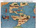
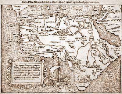
The
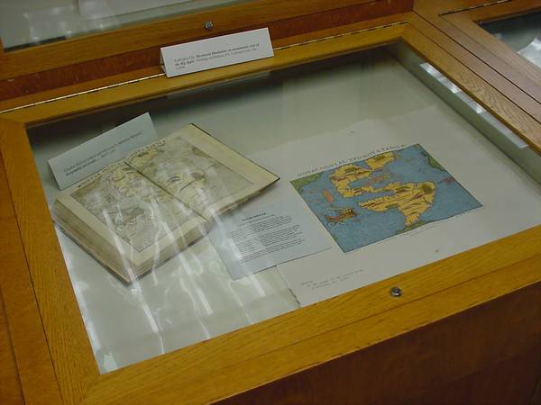
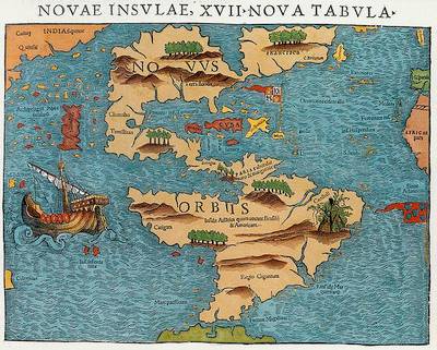
first printed map devoted entirely to the New World.
Copyright
by Dr Zsolt Török, Cartart FacTsimile Publisher, 2003
The map
was published by Dr. Zsolt Török to commemorate the 500th
anniversary of the Columbian encounter.
|
Printing
technology: relief printed from hand
cut wood block with stereotypes
|
TECHNICAL
Specification:
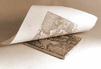
Technique:
relief printed from hand cut wood block with stereotypes
Sheet
size: 520 x 640 mm,
Image
size: 272 x 346 mm
Paper:
special hand made, archival quality, deckle edged
Watermark:
two OT- diagrams and cartart label. Can not be removed.
Color:
every map is individually colored by hand.
Copies
are individually numbered and blind stamped. Special copies are
decorated
with solid gold.
Custom
coloring or uncolored copies are available to request.
Special
gift
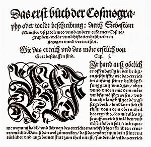
on verso:
the original
Latin text to the map is relief printed between
the two woodcut borders, which were attributed
to Holbein.
Edition
limited to five hundred copies.
up
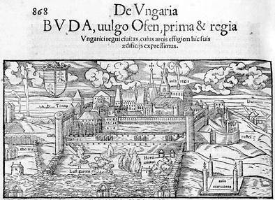
DESCRIPTION:
First
issued inSebastian
Münster's Ptolemy edition of 1540 in Basle (Switzerland),
and included in his most famous Cosmography from 1544, it was the most
popular representation of America.
The
map features the
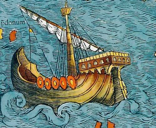
false sea of Verrazzano. Illustrated presumably Magellan's ship
(although there is no resemblance to any vessel he sailed in), a
cannibal
hut (with dismembered human body parts. The Spanish and Portuguese
flags
mark the territories of the European powers.
The
Münster America
Cartart FacTsimile map was published to commemorate the 500th
anniversary
of the Columbian encounter in 1992.
up
Sebastian
Münster (1488 - 1550),
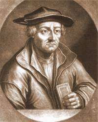 The 'German Strabo', is one
of the most important and famous cosmographers of the 16th century. His
Cosmographia,
published from 1544, was perhaps the most popular illustrated
geographical
work of the century.
Münster was born
in Niederingelheim,
not far from the city of Mainz, where in the 1460s Johannes
Gutenberg
had invented printing from movable metal types. The young Münster
joined the Franciscan Order, and entered the monastery of Rufach
in 1509 to study under Konrad Pellikan, the important German
humanist.
Beyond theology, Pellikan was a teacher of Hebrew, Greek, mathematics
and
cosmography and Münster interested in these subjects. In 1511,
when
Pellikan moved to Pforzheim Münster followed him.
In 1514
Münster
left for Tübingen, where he met the famous professor, Johannes
Stöffler, an eminent scholar of mathematics and astronomy. It
was Stöffler, who introduced Münster into cosmography.
From about 1515-1518 Münster's lecture note book (Kollegienbuch)
has been preserved, which contains extracts from various publications
with
commentary, but also includes manuscript maps copied by
Münster.
From 1524 Münster
moved
to
Heidelberg where he was appointed professor of Hebrew. His
permanent
cosmographical interest is reflected by his lectures at the university
and his published map of Germany (Oppelheim,1525) , as well as
his
treatise on sundials (Erklerung des newen Instrument der Sunnen, 1528).
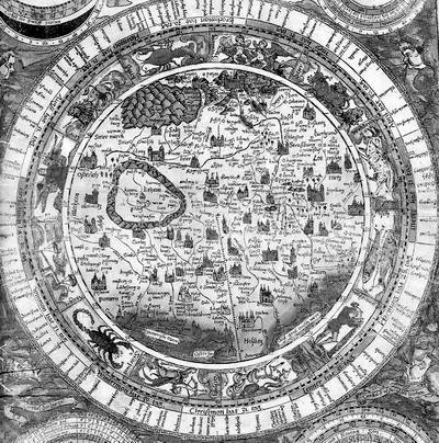 The second part of the booklet
explains chorographical map making techniques. To illustrate the
surveying
methods, Münster included an explanatory circular map of the
environs
of Heidelberg, to a radius of 6 German miles. In the end he suggested
similar
surveys to be undertaken by German scholars (Vermanung). Based
on
the regional maps of German lands he wanted to compile the new, more
accurate
and detailed map of the whole of Germany. At this point Münster
apparently
broke the Ptolemaic tradition of map making.
The second part of the booklet
explains chorographical map making techniques. To illustrate the
surveying
methods, Münster included an explanatory circular map of the
environs
of Heidelberg, to a radius of 6 German miles. In the end he suggested
similar
surveys to be undertaken by German scholars (Vermanung). Based
on
the regional maps of German lands he wanted to compile the new, more
accurate
and detailed map of the whole of Germany. At this point Münster
apparently
broke the Ptolemaic tradition of map making.
However, he did not reject
the Alexandrian scholar: in 1540 he published the famous Geography by
Ptolemy
in new translation.The influential book was printed by the Petri
workshop
in Basle. In 1529 he was offered a position at the university of
Basle by the influential Swiss humanist, Johann Oecolampadius. He
had previously lived and worked in this city for the local printer Heinrich
Petri. In 1530, Münster married Sebastian Petri'swidow,
and he worked with his stepson running the printing workshop.
In the May of 1550 Münster
died of plague in Basle and was buried in the there, but his works
remained
influential in the period of the next generation of great modern
map makers
.
up
SUBSCRIPTION:
The
map is still available.
For more information,
a free demonstrative sample of the product and/ or the Order Form
please, send a message with your name and mailing address to
the Publisher.
up
REFERENCES:
Special
copies of
Münster America maps have been presented to:
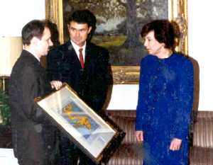 Presentation to Carla Hills, US Trade Representative, Presentation to Carla Hills, US Trade Representative,
in
Washington, D.C.
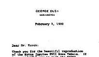 Letter from Mr. George Bush,
President of the United States of America (1993) Letter from Mr. George Bush,
President of the United States of America (1993)
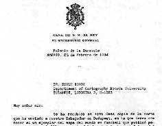 His Majesty
Juan Carlos,
King of Spain (1992) His Majesty
Juan Carlos,
King of Spain (1992)
The
1992 edition Münster
America map was donated to several major map collections and libraries
worldwide, special copies are in the collection of:
- Széchényi
National Library,
Budapest
- Hungarian Embassy in
Washington,
D.C.
- Library of Congress,
- American
Geographical Society,
- Harvard Map
Collection,
- UCLA Bruman
Library,
- Yale University
Library,
- Newberry Library,
- Thuderbird Graduate
School and much more...
up
US
MAP GIFT Project:
September,
2003 - Gift copy (8) has just been presented to the Library
of University of Texas, Arlington!
No
answer, no photo has been received...
US
Map Gift - Report
The
first Münster America quincentennial edition map gift was sent to
(1)the
American
Geographical Society's Collection in
Milwaukee,
WI, where the creator was one time Research Fellow.

American Geographical Society's Collection,
September 11, 2002
(2)It
is a great honor the the Map Division
of
Library of Congress, Washington, D.C.,
the largest map collection of the world, would include a gift copy
among
its 4.8 million holdings. It is a special recognition that the map will
be displayed there!

(3
another gift would decorate The
Newberry
Library in Chicago,ILL. (Remark: copy
lost on its way, another copy had been sen and arrivedt.).

(4)Harvard
Map Collection, Cambridge, Mass.

(5)
Osher Map Library and Smith Center for Cartographic Education
in Portland, Maine were also presented by a Münster America
map. Upon cataloging the items will be held in these finest collections
of early maps. I have seen my gift map framed and dispalyed in the
reading room!

(6)
The New Jersey Historical Society,
Newark, N.J. received a gift as contribution to thememorial
exhibition 'Changed
Lives', opening on September 11,
2002
.
(7)
One
copy was donated to the Library of
Virginia,
Richmond,
VA, which will be on display with the
library's
original Bill of Rights on the Day of Remembrance.
 in September
2002 -
in September
2002 -
Bill of Rights
on
Rare Public Display At Library of Virginia For Day of Remembrance
From press
release of the Library of Virginia
The
Library of Virginia, September 11,
2002
(Richmond, VA) -- On September 11, 2002, the
Library of Virginia will join museums across the nation in a Day of
Remembrance
of the tragic events of September 11, 2001. The federal Institute of
Museum
and Library Services (IMLS)
and the American Association of Museums
(AAM)
are supporting American museums as they Celebrate Americas Freedoms
in a Day of Remembrance on September 11. The Library will
display
Virginia's 1789 manuscript copy of the proposed United States Bill of
Rights,
with its original 12 amendments.
...
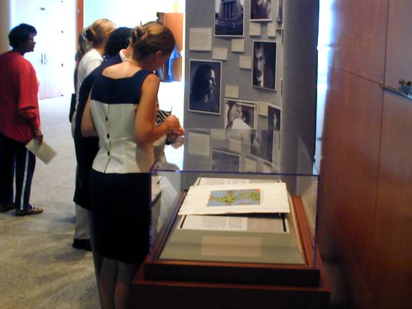
On display will be a copy of the
Münster
America 1540-1992 map, Novae Insulae, XVII Nova Tabula, the first
printed
map devoted entirely to the New World and which appeared in Sebastian
Minster's
1540 edition of Ptolemy’s Geography. Dr. Zsolt Török, a
Hungarian
cartographer, published the map to commemorate the 500th anniversary of
the Columbian Encounter.
Dr. Török donated this copy
printed
from a hand cut wood block on handmade paper to the Library of Virginia
in sympathy for the events of September 11. Copies of the map also have
been donated to a select group of institutions including the Newberry
Library
in Chicago, Harvard Map Collection, American Geographical Society's
Collection
and the Geography and Map Division of the Library of Congress.
Please see our Web site www.lva.lib.va.us
or call 804/692-3592 for more information.
(8)
University
of Texas, Arlington!
(9)
(10)
up
|
|
|
 The
world's only private traditional workshop
The
world's only private traditional workshop